You are here: Home > Network List > KN - Kyrgyz Seismic Telemetry Network Stations List
> Station UCH KN.UCH > Earthquake Result Viewer
UCH KN.UCH - Earthquake Result Viewer

| Earthquake location: |
Irian Jaya, Indonesia |
| Earthquake latitude/longitude: |
-3.1/138.7 |
| Earthquake time(UTC): |
2007/06/16 (167) 21:52:34 GMT |
| Earthquake Depth: |
10 km |
| Earthquake Magnitude: |
5.9 MB, 5.5 MS, 5.7 MW, 5.6 MW |
| Earthquake Catalog/Contributor: |
WHDF/NEIC |
|
| Network: |
KN Kyrgyz Seismic Telemetry Network |
| Station: |
UCH KN.UCH |
| Lat/Lon: |
42.23 N/74.51 E |
| Elevation: |
3850 m |
|
| Distance: |
73.3 deg |
| Az: |
315.723 deg |
| Baz: |
110.18 deg |
| Ray Param: |
0.053072833 |
| Estimated Moho Depth: |
22.5 km |
| Estimated Crust Vp/Vs: |
2.03 |
| Assumed Crust Vp: |
6.306 km/s |
| Estimated Crust Vs: |
3.103 km/s |
| Estimated Crust Poisson's Ratio: |
0.34 |
|
| Radial Match: |
94.58837 % |
| Radial Bump: |
400 |
| Transverse Match: |
90.69263 % |
| Transverse Bump: |
400 |
| SOD ConfigId: |
2564 |
| Insert Time: |
2010-03-08 21:32:01.376 +0000 |
| GWidth: |
2.5 |
| Max Bumps: |
400 |
| Tol: |
0.001 |
|
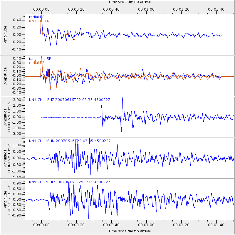
Signal To Noise
| Channel | StoN | STA | LTA |
| KN:UCH: :BHN:20070616T22:03:35.450022Z | 1.750935 | 8.404314E-8 | 4.7999002E-8 |
| KN:UCH: :BHE:20070616T22:03:35.450022Z | 4.516449 | 1.6135394E-7 | 3.5725844E-8 |
| KN:UCH: :BHZ:20070616T22:03:35.450022Z | 11.877529 | 5.6084014E-7 | 4.7218588E-8 |
| Arrivals |
| Ps | 3.8 SECOND |
| PpPs | 11 SECOND |
| PsPs/PpSs | 14 SECOND |


