You are here: Home > Network List > TA - USArray Transportable Network (new EarthScope stations) Stations List
> Station G21K Allakaket, AK, USA > Earthquake Result Viewer
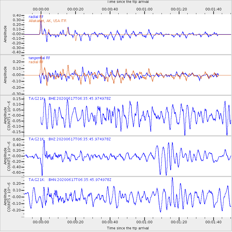
G21K Allakaket, AK, USA - Earthquake Result Viewer
*The percent match for this event was below the threshold and hence no stack was calculated.
| Earthquake location: |
Tonga Islands |
| Earthquake latitude/longitude: |
-16.1/-175.0 |
| Earthquake time(UTC): |
2020/06/17 (169) 06:24:18 GMT |
| Earthquake Depth: |
280 km |
| Earthquake Magnitude: |
5.6 Mww |
| Earthquake Catalog/Contributor: |
NEIC PDE/us |
|
| Network: |
TA USArray Transportable Network (new EarthScope stations) |
| Station: |
G21K Allakaket, AK, USA |
| Lat/Lon: |
66.52 N/153.51 W |
| Elevation: |
446 m |
|
| Distance: |
84.0 deg |
| Az: |
8.485 deg |
| Baz: |
200.724 deg |
| Ray Param: |
$rayparam |
*The percent match for this event was below the threshold and hence was not used in the summary stack. |
|
| Radial Match: |
65.95483 % |
| Radial Bump: |
329 |
| Transverse Match: |
46.910133 % |
| Transverse Bump: |
351 |
| SOD ConfigId: |
21709731 |
| Insert Time: |
2020-07-01 06:41:04.148 +0000 |
| GWidth: |
2.5 |
| Max Bumps: |
400 |
| Tol: |
0.001 |
|
Signal To Noise
| Channel | StoN | STA | LTA |
| TA:G21K: :BHZ:20200617T06:35:45.974978Z | 4.1542983 | 2.9037088E-7 | 6.989649E-8 |
| TA:G21K: :BHN:20200617T06:35:45.974978Z | 1.256679 | 8.4330956E-8 | 6.71062E-8 |
| TA:G21K: :BHE:20200617T06:35:45.974978Z | 0.6907748 | 4.6873986E-8 | 6.7857115E-8 |
| Arrivals |
| Ps | |
| PpPs | |
| PsPs/PpSs | |


