You are here: Home > Network List > US - United States National Seismic Network Stations List
> Station DGMT Dagmar, Montana, USA > Earthquake Result Viewer
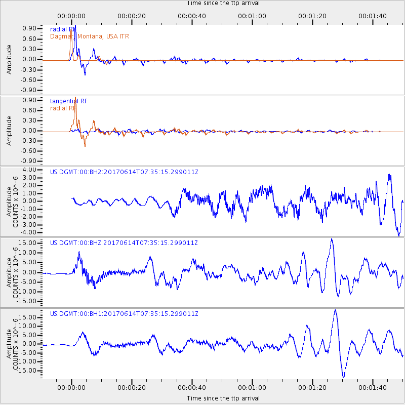
DGMT Dagmar, Montana, USA - Earthquake Result Viewer
*The percent match for this event was below the threshold and hence no stack was calculated.
| Earthquake location: |
Near Coast Of Chiapas, Mexico |
| Earthquake latitude/longitude: |
14.9/-92.0 |
| Earthquake time(UTC): |
2017/06/14 (165) 07:29:03 GMT |
| Earthquake Depth: |
98 km |
| Earthquake Magnitude: |
7.0 Mi |
| Earthquake Catalog/Contributor: |
NEIC PDE/at |
|
| Network: |
US United States National Seismic Network |
| Station: |
DGMT Dagmar, Montana, USA |
| Lat/Lon: |
48.47 N/104.20 W |
| Elevation: |
0.0 m |
|
| Distance: |
35.0 deg |
| Az: |
345.796 deg |
| Baz: |
159.116 deg |
| Ray Param: |
$rayparam |
*The percent match for this event was below the threshold and hence was not used in the summary stack. |
|
| Radial Match: |
97.035484 % |
| Radial Bump: |
227 |
| Transverse Match: |
76.57724 % |
| Transverse Bump: |
400 |
| SOD ConfigId: |
2140511 |
| Insert Time: |
2017-06-27 23:24:17.373 +0000 |
| GWidth: |
2.5 |
| Max Bumps: |
400 |
| Tol: |
0.001 |
|
Signal To Noise
| Channel | StoN | STA | LTA |
| US:DGMT:00:BHZ:20170614T07:35:15.299011Z | 18.48779 | 4.4709523E-6 | 2.4183274E-7 |
| US:DGMT:00:BH1:20170614T07:35:15.299011Z | 11.627524 | 3.562765E-6 | 3.0640788E-7 |
| US:DGMT:00:BH2:20170614T07:35:15.299011Z | 3.239111 | 9.240232E-7 | 2.852706E-7 |
| Arrivals |
| Ps | |
| PpPs | |
| PsPs/PpSs | |


