You are here: Home > Network List > TA - USArray Transportable Network (new EarthScope stations) Stations List
> Station I30M Mount Dempster, Yukon, CAN > Earthquake Result Viewer
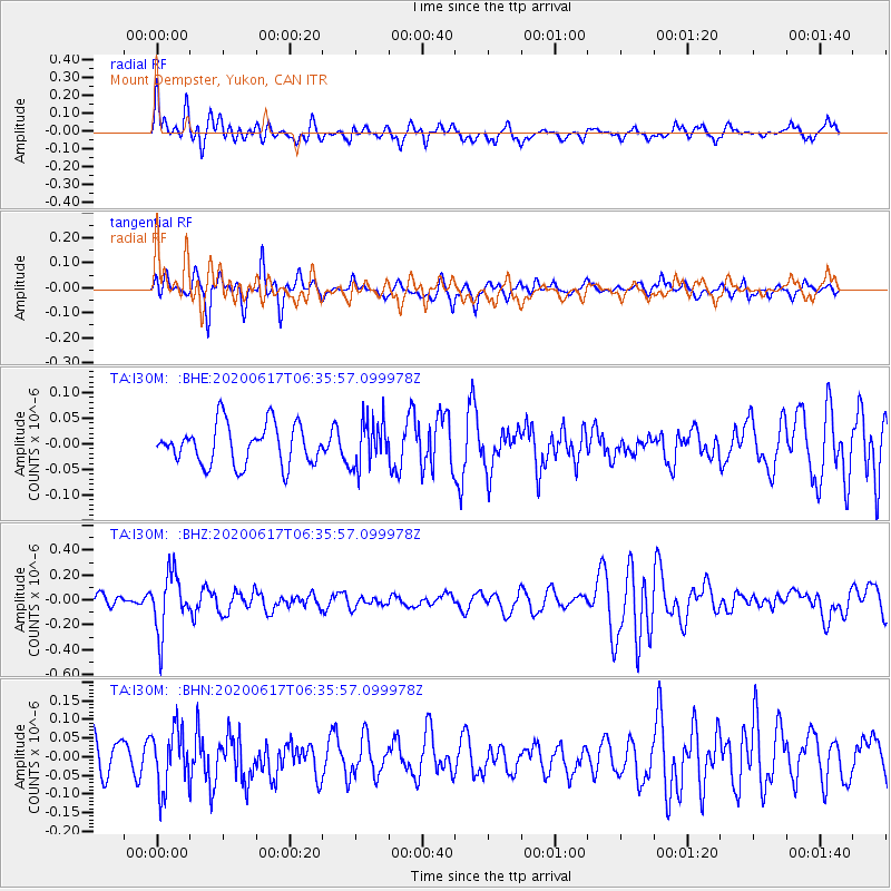
I30M Mount Dempster, Yukon, CAN - Earthquake Result Viewer
*The percent match for this event was below the threshold and hence no stack was calculated.
| Earthquake location: |
Tonga Islands |
| Earthquake latitude/longitude: |
-16.1/-175.0 |
| Earthquake time(UTC): |
2020/06/17 (169) 06:24:18 GMT |
| Earthquake Depth: |
280 km |
| Earthquake Magnitude: |
5.6 Mww |
| Earthquake Catalog/Contributor: |
NEIC PDE/us |
|
| Network: |
TA USArray Transportable Network (new EarthScope stations) |
| Station: |
I30M Mount Dempster, Yukon, CAN |
| Lat/Lon: |
65.22 N/136.38 W |
| Elevation: |
1399 m |
|
| Distance: |
86.2 deg |
| Az: |
15.28 deg |
| Baz: |
216.941 deg |
| Ray Param: |
$rayparam |
*The percent match for this event was below the threshold and hence was not used in the summary stack. |
|
| Radial Match: |
65.533295 % |
| Radial Bump: |
400 |
| Transverse Match: |
59.12367 % |
| Transverse Bump: |
324 |
| SOD ConfigId: |
21709731 |
| Insert Time: |
2020-07-01 06:41:30.643 +0000 |
| GWidth: |
2.5 |
| Max Bumps: |
400 |
| Tol: |
0.001 |
|
Signal To Noise
| Channel | StoN | STA | LTA |
| TA:I30M: :BHZ:20200617T06:35:57.099978Z | 5.01614 | 2.3440532E-7 | 4.6730214E-8 |
| TA:I30M: :BHN:20200617T06:35:57.099978Z | 1.6322705 | 7.87199E-8 | 4.8227243E-8 |
| TA:I30M: :BHE:20200617T06:35:57.099978Z | 1.1591935 | 4.5534517E-8 | 3.9281204E-8 |
| Arrivals |
| Ps | |
| PpPs | |
| PsPs/PpSs | |


