You are here: Home > Network List > US - United States National Seismic Network Stations List
> Station ELK Elko, Nevada, USA > Earthquake Result Viewer
ELK Elko, Nevada, USA - Earthquake Result Viewer
| Earthquake location: |
Near Coast Of Chiapas, Mexico |
| Earthquake latitude/longitude: |
14.9/-92.0 |
| Earthquake time(UTC): |
2017/06/14 (165) 07:29:03 GMT |
| Earthquake Depth: |
98 km |
| Earthquake Magnitude: |
7.0 Mi |
| Earthquake Catalog/Contributor: |
NEIC PDE/at |
|
| Network: |
US United States National Seismic Network |
| Station: |
ELK Elko, Nevada, USA |
| Lat/Lon: |
40.74 N/115.24 W |
| Elevation: |
2210 m |
|
| Distance: |
32.7 deg |
| Az: |
326.34 deg |
| Baz: |
135.148 deg |
| Ray Param: |
0.07825182 |
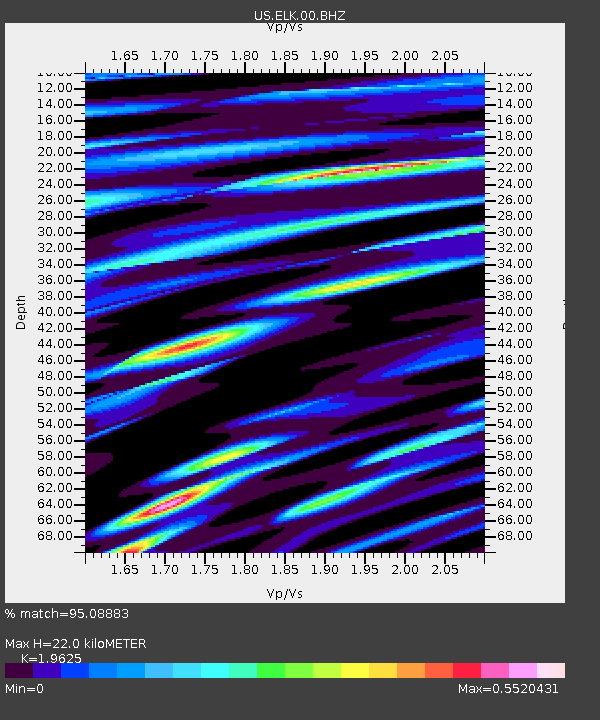
| Estimated Moho Depth: |
22.0 km |
| Estimated Crust Vp/Vs: |
1.96 |
| Assumed Crust Vp: |
6.276 km/s |
| Estimated Crust Vs: |
3.198 km/s |
| Estimated Crust Poisson's Ratio: |
0.32 |
|
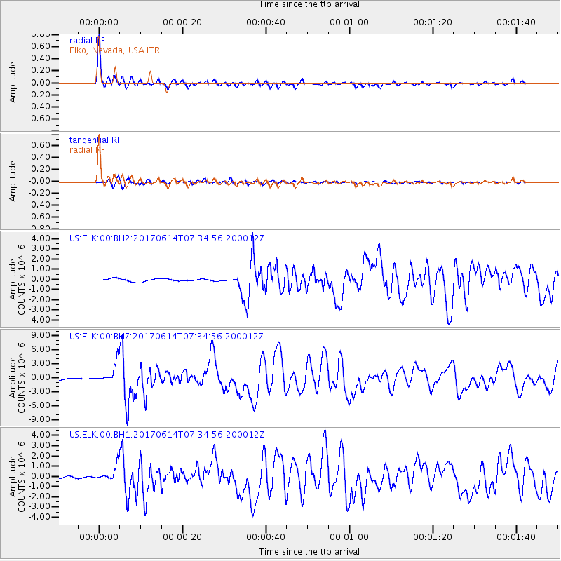
| Radial Match: |
95.08883 % |
| Radial Bump: |
356 |
| Transverse Match: |
82.784004 % |
| Transverse Bump: |
400 |
| SOD ConfigId: |
2140511 |
| Insert Time: |
2017-06-27 23:24:22.675 +0000 |
| GWidth: |
2.5 |
| Max Bumps: |
400 |
| Tol: |
0.001 |
|
Signal To Noise
| Channel | StoN | STA | LTA |
| US:ELK:00:BHZ:20170614T07:34:56.200012Z | 15.228057 | 2.226352E-6 | 1.4620068E-7 |
| US:ELK:00:BH1:20170614T07:34:56.200012Z | 6.6284323 | 7.478598E-7 | 1.12826044E-7 |
| US:ELK:00:BH2:20170614T07:34:56.200012Z | 5.8043113 | 7.7115703E-7 | 1.3285936E-7 |
| Arrivals |
| Ps | 3.6 SECOND |
| PpPs | 9.7 SECOND |
| PsPs/PpSs | 13 SECOND |


