You are here: Home > Network List > US - United States National Seismic Network Stations List
> Station EGMT Eagleton, Montana, USA > Earthquake Result Viewer
EGMT Eagleton, Montana, USA - Earthquake Result Viewer
| Earthquake location: |
Near Coast Of Chiapas, Mexico |
| Earthquake latitude/longitude: |
14.9/-92.0 |
| Earthquake time(UTC): |
2017/06/14 (165) 07:29:03 GMT |
| Earthquake Depth: |
98 km |
| Earthquake Magnitude: |
7.0 Mi |
| Earthquake Catalog/Contributor: |
NEIC PDE/at |
|
| Network: |
US United States National Seismic Network |
| Station: |
EGMT Eagleton, Montana, USA |
| Lat/Lon: |
48.02 N/109.75 W |
| Elevation: |
1055 m |
|
| Distance: |
36.1 deg |
| Az: |
339.694 deg |
| Baz: |
150.013 deg |
| Ray Param: |
0.076523684 |
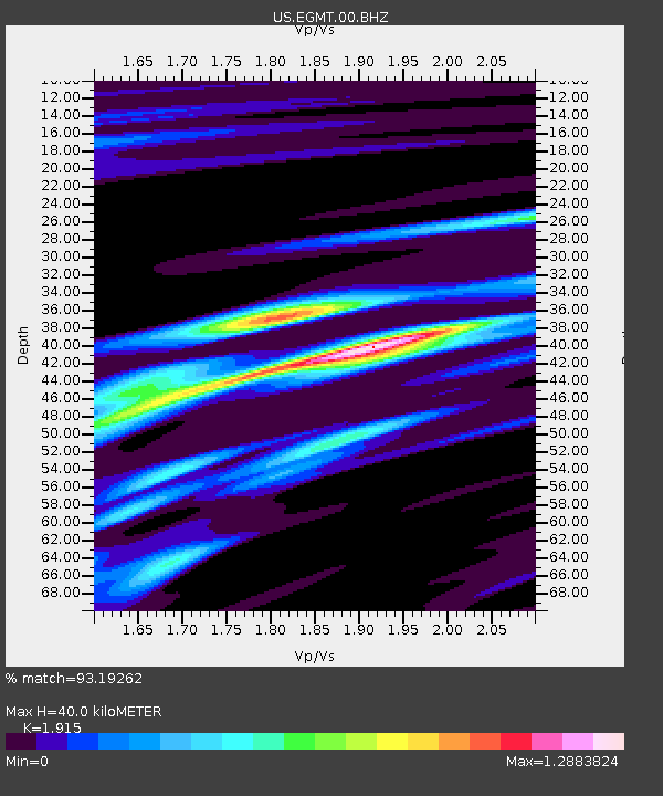
| Estimated Moho Depth: |
40.0 km |
| Estimated Crust Vp/Vs: |
1.91 |
| Assumed Crust Vp: |
6.438 km/s |
| Estimated Crust Vs: |
3.362 km/s |
| Estimated Crust Poisson's Ratio: |
0.31 |
|
| Radial Match: |
93.19262 % |
| Radial Bump: |
295 |
| Transverse Match: |
69.35898 % |
| Transverse Bump: |
400 |
| SOD ConfigId: |
2140511 |
| Insert Time: |
2017-06-27 23:24:33.205 +0000 |
| GWidth: |
2.5 |
| Max Bumps: |
400 |
| Tol: |
0.001 |
|
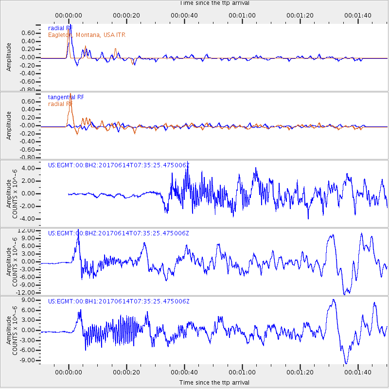
Signal To Noise
| Channel | StoN | STA | LTA |
| US:EGMT:00:BHZ:20170614T07:35:25.475006Z | 21.192389 | 4.497948E-6 | 2.1224355E-7 |
| US:EGMT:00:BH1:20170614T07:35:25.475006Z | 13.487279 | 2.6901898E-6 | 1.9946128E-7 |
| US:EGMT:00:BH2:20170614T07:35:25.475006Z | 5.663392 | 1.1906517E-6 | 2.1023651E-7 |
| Arrivals |
| Ps | 6.1 SECOND |
| PpPs | 17 SECOND |
| PsPs/PpSs | 23 SECOND |


