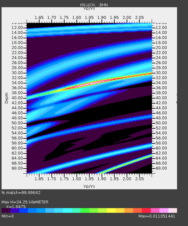
UCH KN.UCH - Earthquake Result Viewer
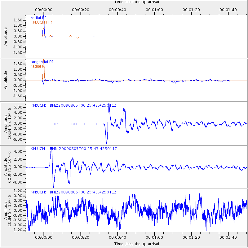
Earthquake location: Southwestern Ryukyu Isl., Japan
Earthquake latitude/longitude: 24.2/125.1
Earthquake time(UTC): 2009/08/05 (217) 00:17:58 GMT
Earthquake Depth: 25 km
Earthquake Magnitude: 5.9 MB, 5.9 MS, 6.2 MW, 6.1 MW
Earthquake Catalog/Contributor: WHDF/NEIC
Network: KN Kyrgyz Seismic Telemetry Network
Station: UCH KN.UCH
Lat/Lon: 42.23 N/74.51 E
Elevation: 3850 m
Distance: 45.3 deg
Az: 306.125 deg
Baz: 96.873 deg
Ray Param: 0.07135034
Estimated Moho Depth: 34.25 km
Estimated Crust Vp/Vs: 1.85
Assumed Crust Vp: 6.306 km/s
Estimated Crust Vs: 3.413 km/s
Estimated Crust Poisson's Ratio: 0.29
Radial Match: 99.89842 %
Radial Bump: 17
Transverse Match: 67.005714 %
Transverse Bump: 400
SOD ConfigId: 2622
Insert Time: 2010-03-08 21:32:23.547 +0000
GWidth: 2.5
Max Bumps: 400
Tol: 0.001

Signal To Noise

ChannelStoNSTALTA
KN:UCH: :BHN:20090805T00:25:43.425011Z87.1391.884127E-62.1622085E-8
KN:UCH: :BHE:20090805T00:25:43.425011Z0.794600373.6718794E-74.621039E-7
KN:UCH: :BHZ:20090805T00:25:43.425011Z95.586032.6492542E-62.7715915E-8
Arrivals
Ps4.9 SECOND
PpPs15 SECOND
PsPs/PpSs19 SECOND