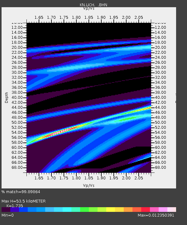
UCH KN.UCH - Earthquake Result Viewer
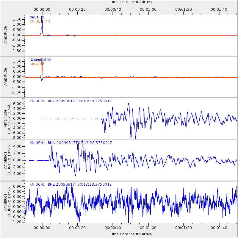
Earthquake location: Southwestern Ryukyu Isl., Japan
Earthquake latitude/longitude: 23.5/123.5
Earthquake time(UTC): 2009/08/17 (229) 00:05:49 GMT
Earthquake Depth: 20 km
Earthquake Magnitude: 6.2 MB, 6.6 MS, 6.7 MW, 6.6 MW
Earthquake Catalog/Contributor: WHDF/NEIC
Network: KN Kyrgyz Seismic Telemetry Network
Station: UCH KN.UCH
Lat/Lon: 42.23 N/74.51 E
Elevation: 3850 m
Distance: 44.5 deg
Az: 306.944 deg
Baz: 98.934 deg
Ray Param: 0.07183847
Estimated Moho Depth: 53.5 km
Estimated Crust Vp/Vs: 1.74
Assumed Crust Vp: 6.306 km/s
Estimated Crust Vs: 3.635 km/s
Estimated Crust Poisson's Ratio: 0.25
Radial Match: 99.89864 %
Radial Bump: 14
Transverse Match: 69.69534 %
Transverse Bump: 400
SOD ConfigId: 2622
Insert Time: 2010-03-08 21:32:31.279 +0000
GWidth: 2.5
Max Bumps: 400
Tol: 0.001

Signal To Noise

ChannelStoNSTALTA
KN:UCH: :BHN:20090817T00:13:28.375001Z10.1207933.8543052E-73.8083037E-8
KN:UCH: :BHE:20090817T00:13:28.375001Z1.16887784.6581664E-73.985161E-7
KN:UCH: :BHZ:20090817T00:13:28.375001Z10.8249215.487813E-75.06961E-8
Arrivals
Ps6.6 SECOND
PpPs22 SECOND
PsPs/PpSs28 SECOND