You are here: Home > Network List > US - United States National Seismic Network Stations List
> Station LAO LASA Array, Montana, USA > Earthquake Result Viewer
LAO LASA Array, Montana, USA - Earthquake Result Viewer
| Earthquake location: |
Near Coast Of Chiapas, Mexico |
| Earthquake latitude/longitude: |
14.9/-92.0 |
| Earthquake time(UTC): |
2017/06/14 (165) 07:29:03 GMT |
| Earthquake Depth: |
98 km |
| Earthquake Magnitude: |
7.0 Mi |
| Earthquake Catalog/Contributor: |
NEIC PDE/at |
|
| Network: |
US United States National Seismic Network |
| Station: |
LAO LASA Array, Montana, USA |
| Lat/Lon: |
46.69 N/106.22 W |
| Elevation: |
902 m |
|
| Distance: |
33.9 deg |
| Az: |
342.324 deg |
| Baz: |
154.758 deg |
| Ray Param: |
0.077738754 |
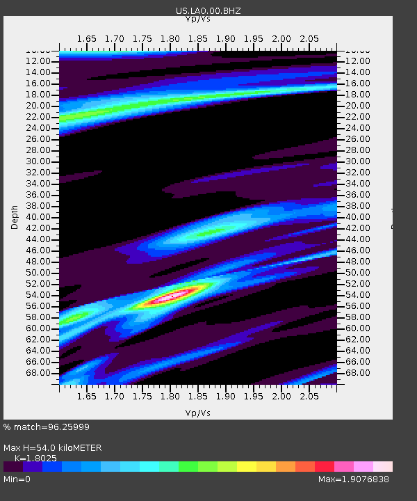
| Estimated Moho Depth: |
54.0 km |
| Estimated Crust Vp/Vs: |
1.80 |
| Assumed Crust Vp: |
6.438 km/s |
| Estimated Crust Vs: |
3.571 km/s |
| Estimated Crust Poisson's Ratio: |
0.28 |
|
| Radial Match: |
96.25999 % |
| Radial Bump: |
251 |
| Transverse Match: |
70.21721 % |
| Transverse Bump: |
378 |
| SOD ConfigId: |
2140511 |
| Insert Time: |
2017-06-27 23:24:42.547 +0000 |
| GWidth: |
2.5 |
| Max Bumps: |
400 |
| Tol: |
0.001 |
|

Signal To Noise
| Channel | StoN | STA | LTA |
| US:LAO:00:BHZ:20170614T07:35:05.799988Z | 19.60575 | 3.9381353E-6 | 2.0086635E-7 |
| US:LAO:00:BH1:20170614T07:35:05.799988Z | 6.3380675 | 2.0617606E-6 | 3.2529798E-7 |
| US:LAO:00:BH2:20170614T07:35:05.799988Z | 7.542324 | 2.80296E-6 | 3.716308E-7 |
| Arrivals |
| Ps | 7.3 SECOND |
| PpPs | 22 SECOND |
| PsPs/PpSs | 29 SECOND |


