You are here: Home > Network List > AK - Alaska Regional Network Stations List
> Station BRLK Bradley Lake > Earthquake Result Viewer
BRLK Bradley Lake - Earthquake Result Viewer
| Earthquake location: |
South Of Kermadec Islands |
| Earthquake latitude/longitude: |
-33.3/-177.8 |
| Earthquake time(UTC): |
2020/06/18 (170) 12:49:53 GMT |
| Earthquake Depth: |
10 km |
| Earthquake Magnitude: |
7.4 Mww |
| Earthquake Catalog/Contributor: |
NEIC PDE/us |
|
| Network: |
AK Alaska Regional Network |
| Station: |
BRLK Bradley Lake |
| Lat/Lon: |
59.75 N/150.91 W |
| Elevation: |
409 m |
|
| Distance: |
95.3 deg |
| Az: |
13.316 deg |
| Baz: |
202.396 deg |
| Ray Param: |
0.040818337 |
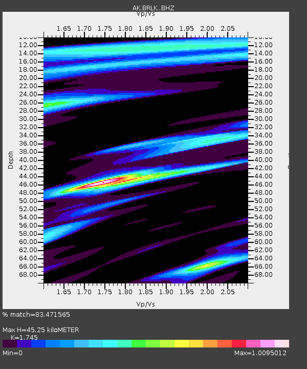
| Estimated Moho Depth: |
45.25 km |
| Estimated Crust Vp/Vs: |
1.75 |
| Assumed Crust Vp: |
6.24 km/s |
| Estimated Crust Vs: |
3.576 km/s |
| Estimated Crust Poisson's Ratio: |
0.26 |
|
| Radial Match: |
83.471565 % |
| Radial Bump: |
400 |
| Transverse Match: |
73.14758 % |
| Transverse Bump: |
400 |
| SOD ConfigId: |
21709731 |
| Insert Time: |
2020-07-02 12:50:58.518 +0000 |
| GWidth: |
2.5 |
| Max Bumps: |
400 |
| Tol: |
0.001 |
|

Signal To Noise
| Channel | StoN | STA | LTA |
| AK:BRLK: :BHZ:20200618T13:02:46.307974Z | 6.132049 | 3.137687E-6 | 5.1168655E-7 |
| AK:BRLK: :BHN:20200618T13:02:46.307974Z | 3.201289 | 1.0268986E-6 | 3.2077662E-7 |
| AK:BRLK: :BHE:20200618T13:02:46.307974Z | 1.9006898 | 6.112089E-7 | 3.2157214E-7 |
| Arrivals |
| Ps | 5.5 SECOND |
| PpPs | 20 SECOND |
| PsPs/PpSs | 25 SECOND |


