You are here: Home > Network List > US - United States National Seismic Network Stations List
> Station LONY Lake Ozonia, New York, USA > Earthquake Result Viewer
LONY Lake Ozonia, New York, USA - Earthquake Result Viewer
| Earthquake location: |
Near Coast Of Chiapas, Mexico |
| Earthquake latitude/longitude: |
14.9/-92.0 |
| Earthquake time(UTC): |
2017/06/14 (165) 07:29:03 GMT |
| Earthquake Depth: |
98 km |
| Earthquake Magnitude: |
7.0 Mi |
| Earthquake Catalog/Contributor: |
NEIC PDE/at |
|
| Network: |
US United States National Seismic Network |
| Station: |
LONY Lake Ozonia, New York, USA |
| Lat/Lon: |
44.62 N/74.58 W |
| Elevation: |
440 m |
|
| Distance: |
33.1 deg |
| Az: |
23.038 deg |
| Baz: |
211.992 deg |
| Ray Param: |
0.0780849 |
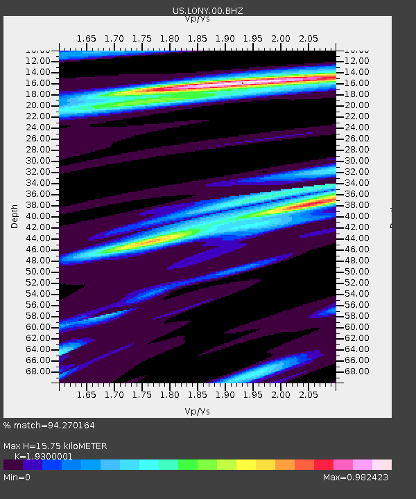
| Estimated Moho Depth: |
15.75 km |
| Estimated Crust Vp/Vs: |
1.93 |
| Assumed Crust Vp: |
6.419 km/s |
| Estimated Crust Vs: |
3.326 km/s |
| Estimated Crust Poisson's Ratio: |
0.32 |
|
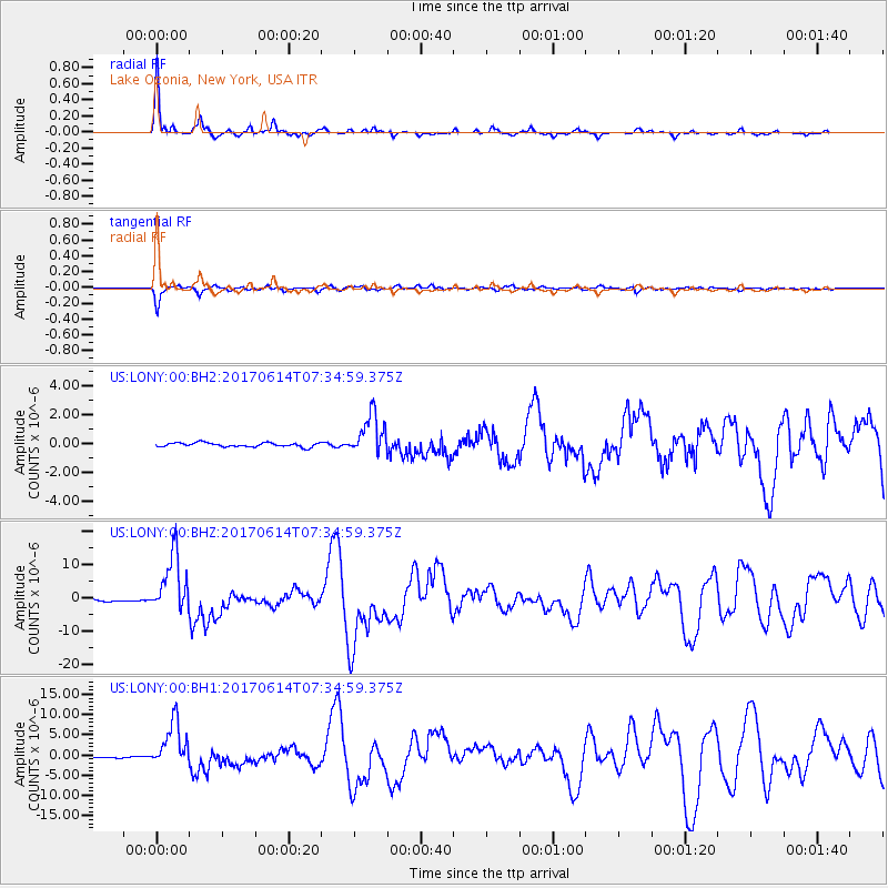
| Radial Match: |
94.270164 % |
| Radial Bump: |
261 |
| Transverse Match: |
90.14493 % |
| Transverse Bump: |
341 |
| SOD ConfigId: |
2140511 |
| Insert Time: |
2017-06-27 23:24:45.005 +0000 |
| GWidth: |
2.5 |
| Max Bumps: |
400 |
| Tol: |
0.001 |
|
Signal To Noise
| Channel | StoN | STA | LTA |
| US:LONY:00:BHZ:20170614T07:34:59.375Z | 37.972496 | 8.864923E-6 | 2.3345642E-7 |
| US:LONY:00:BH1:20170614T07:34:59.375Z | 26.805208 | 5.5658375E-6 | 2.0764014E-7 |
| US:LONY:00:BH2:20170614T07:34:59.375Z | 10.125214 | 1.4147025E-6 | 1.3972075E-7 |
| Arrivals |
| Ps | 2.4 SECOND |
| PpPs | 6.7 SECOND |
| PsPs/PpSs | 9.1 SECOND |


