You are here: Home > Network List > AK - Alaska Regional Network Stations List
> Station HOM Homer Trailer > Earthquake Result Viewer
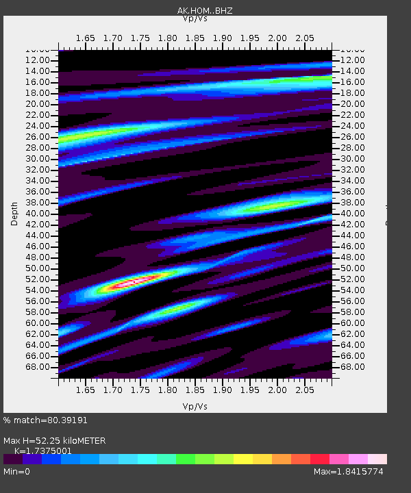
HOM Homer Trailer - Earthquake Result Viewer
| Earthquake location: |
South Of Kermadec Islands |
| Earthquake latitude/longitude: |
-33.3/-177.8 |
| Earthquake time(UTC): |
2020/06/18 (170) 12:49:53 GMT |
| Earthquake Depth: |
10 km |
| Earthquake Magnitude: |
7.4 Mww |
| Earthquake Catalog/Contributor: |
NEIC PDE/us |
|
| Network: |
AK Alaska Regional Network |
| Station: |
HOM Homer Trailer |
| Lat/Lon: |
59.66 N/151.65 W |
| Elevation: |
221 m |
|
| Distance: |
95.1 deg |
| Az: |
13.0 deg |
| Baz: |
201.784 deg |
| Ray Param: |
0.04087758 |
| Estimated Moho Depth: |
52.25 km |
| Estimated Crust Vp/Vs: |
1.74 |
| Assumed Crust Vp: |
6.24 km/s |
| Estimated Crust Vs: |
3.591 km/s |
| Estimated Crust Poisson's Ratio: |
0.25 |
|
| Radial Match: |
80.39191 % |
| Radial Bump: |
400 |
| Transverse Match: |
72.60628 % |
| Transverse Bump: |
400 |
| SOD ConfigId: |
21709731 |
| Insert Time: |
2020-07-02 12:51:29.361 +0000 |
| GWidth: |
2.5 |
| Max Bumps: |
400 |
| Tol: |
0.001 |
|

Signal To Noise
| Channel | StoN | STA | LTA |
| AK:HOM: :BHZ:20200618T13:02:45.267996Z | 4.2618594 | 4.067718E-6 | 9.544467E-7 |
| AK:HOM: :BHN:20200618T13:02:45.267996Z | 1.7333457 | 1.7251394E-6 | 9.952656E-7 |
| AK:HOM: :BHE:20200618T13:02:45.267996Z | 1.3938868 | 1.3646448E-6 | 9.790214E-7 |
| Arrivals |
| Ps | 6.3 SECOND |
| PpPs | 22 SECOND |
| PsPs/PpSs | 29 SECOND |


