You are here: Home > Network List > AK - Alaska Regional Network Stations List
> Station KIAG Kiagna River, AK, USA > Earthquake Result Viewer
KIAG Kiagna River, AK, USA - Earthquake Result Viewer
| Earthquake location: |
South Of Kermadec Islands |
| Earthquake latitude/longitude: |
-33.3/-177.8 |
| Earthquake time(UTC): |
2020/06/18 (170) 12:49:53 GMT |
| Earthquake Depth: |
10 km |
| Earthquake Magnitude: |
7.4 Mww |
| Earthquake Catalog/Contributor: |
NEIC PDE/us |
|
| Network: |
AK Alaska Regional Network |
| Station: |
KIAG Kiagna River, AK, USA |
| Lat/Lon: |
60.92 N/142.36 W |
| Elevation: |
1773 m |
|
| Distance: |
98.3 deg |
| Az: |
16.647 deg |
| Baz: |
209.419 deg |
| Ray Param: |
0.039960332 |
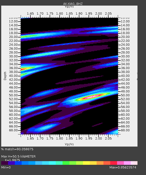
| Estimated Moho Depth: |
50.5 km |
| Estimated Crust Vp/Vs: |
1.97 |
| Assumed Crust Vp: |
6.566 km/s |
| Estimated Crust Vs: |
3.337 km/s |
| Estimated Crust Poisson's Ratio: |
0.33 |
|
| Radial Match: |
90.059875 % |
| Radial Bump: |
400 |
| Transverse Match: |
78.002304 % |
| Transverse Bump: |
400 |
| SOD ConfigId: |
21709731 |
| Insert Time: |
2020-07-02 12:51:36.392 +0000 |
| GWidth: |
2.5 |
| Max Bumps: |
400 |
| Tol: |
0.001 |
|

Signal To Noise
| Channel | StoN | STA | LTA |
| AK:KIAG: :BHZ:20200618T13:02:59.348013Z | 9.042344 | 1.6197913E-6 | 1.7913402E-7 |
| AK:KIAG: :BHN:20200618T13:02:59.348013Z | 1.9780438 | 3.0386053E-7 | 1.5361668E-7 |
| AK:KIAG: :BHE:20200618T13:02:59.348013Z | 1.7663633 | 2.92438E-7 | 1.6555937E-7 |
| Arrivals |
| Ps | 7.6 SECOND |
| PpPs | 22 SECOND |
| PsPs/PpSs | 30 SECOND |


