You are here: Home > Network List > AK - Alaska Regional Network Stations List
> Station SCM Sheep Mountain > Earthquake Result Viewer
SCM Sheep Mountain - Earthquake Result Viewer
| Earthquake location: |
South Of Kermadec Islands |
| Earthquake latitude/longitude: |
-33.3/-177.8 |
| Earthquake time(UTC): |
2020/06/18 (170) 12:49:53 GMT |
| Earthquake Depth: |
10 km |
| Earthquake Magnitude: |
7.4 Mww |
| Earthquake Catalog/Contributor: |
NEIC PDE/us |
|
| Network: |
AK Alaska Regional Network |
| Station: |
SCM Sheep Mountain |
| Lat/Lon: |
61.83 N/147.33 W |
| Elevation: |
1056 m |
|
| Distance: |
98.0 deg |
| Az: |
14.079 deg |
| Baz: |
205.428 deg |
| Ray Param: |
0.040053662 |
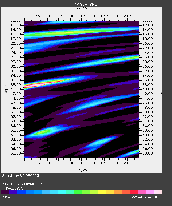
| Estimated Moho Depth: |
37.5 km |
| Estimated Crust Vp/Vs: |
1.69 |
| Assumed Crust Vp: |
6.566 km/s |
| Estimated Crust Vs: |
3.891 km/s |
| Estimated Crust Poisson's Ratio: |
0.23 |
|
| Radial Match: |
82.080215 % |
| Radial Bump: |
400 |
| Transverse Match: |
62.438263 % |
| Transverse Bump: |
400 |
| SOD ConfigId: |
21709731 |
| Insert Time: |
2020-07-02 12:52:17.128 +0000 |
| GWidth: |
2.5 |
| Max Bumps: |
400 |
| Tol: |
0.001 |
|

Signal To Noise
| Channel | StoN | STA | LTA |
| AK:SCM: :BHZ:20200618T13:02:58.048025Z | 9.538147 | 2.253601E-6 | 2.3627241E-7 |
| AK:SCM: :BHN:20200618T13:02:58.048025Z | 3.4304428 | 8.4757033E-7 | 2.4707316E-7 |
| AK:SCM: :BHE:20200618T13:02:58.048025Z | 3.1029558 | 6.064246E-7 | 1.9543448E-7 |
| Arrivals |
| Ps | 4.0 SECOND |
| PpPs | 15 SECOND |
| PsPs/PpSs | 19 SECOND |


