You are here: Home > Network List > AK - Alaska Regional Network Stations List
> Station U33K Whale Pass, AK, USA > Earthquake Result Viewer
U33K Whale Pass, AK, USA - Earthquake Result Viewer
| Earthquake location: |
South Of Kermadec Islands |
| Earthquake latitude/longitude: |
-33.3/-177.8 |
| Earthquake time(UTC): |
2020/06/18 (170) 12:49:53 GMT |
| Earthquake Depth: |
10 km |
| Earthquake Magnitude: |
7.4 Mww |
| Earthquake Catalog/Contributor: |
NEIC PDE/us |
|
| Network: |
AK Alaska Regional Network |
| Station: |
U33K Whale Pass, AK, USA |
| Lat/Lon: |
56.11 N/133.12 W |
| Elevation: |
11 m |
|
| Distance: |
96.8 deg |
| Az: |
23.387 deg |
| Baz: |
216.409 deg |
| Ray Param: |
0.040396076 |
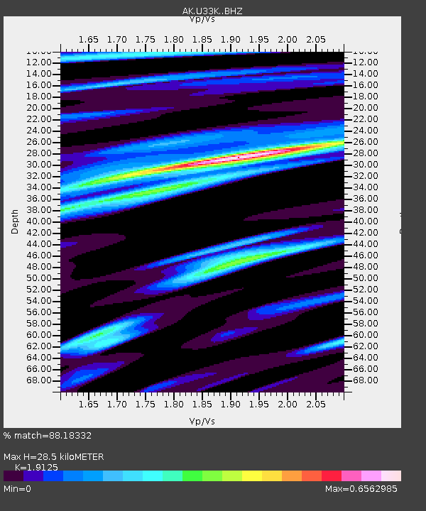
| Estimated Moho Depth: |
28.5 km |
| Estimated Crust Vp/Vs: |
1.91 |
| Assumed Crust Vp: |
6.597 km/s |
| Estimated Crust Vs: |
3.45 km/s |
| Estimated Crust Poisson's Ratio: |
0.31 |
|
| Radial Match: |
88.18332 % |
| Radial Bump: |
400 |
| Transverse Match: |
71.97091 % |
| Transverse Bump: |
400 |
| SOD ConfigId: |
21709731 |
| Insert Time: |
2020-07-02 12:52:28.233 +0000 |
| GWidth: |
2.5 |
| Max Bumps: |
400 |
| Tol: |
0.001 |
|

Signal To Noise
| Channel | StoN | STA | LTA |
| AK:U33K: :BHZ:20200618T13:02:53.080008Z | 5.438898 | 1.2743786E-6 | 2.3430825E-7 |
| AK:U33K: :BHN:20200618T13:02:53.080008Z | 2.1236243 | 5.258768E-7 | 2.4763176E-7 |
| AK:U33K: :BHE:20200618T13:02:53.080008Z | 1.5627232 | 4.3420326E-7 | 2.778504E-7 |
| Arrivals |
| Ps | 4.0 SECOND |
| PpPs | 12 SECOND |
| PsPs/PpSs | 16 SECOND |


