You are here: Home > Network List > AT - Alaska Tsunami Warning Seismic System Stations List
> Station SMY Shemya, Alaska > Earthquake Result Viewer
SMY Shemya, Alaska - Earthquake Result Viewer
| Earthquake location: |
South Of Kermadec Islands |
| Earthquake latitude/longitude: |
-33.3/-177.8 |
| Earthquake time(UTC): |
2020/06/18 (170) 12:49:53 GMT |
| Earthquake Depth: |
10 km |
| Earthquake Magnitude: |
7.4 Mww |
| Earthquake Catalog/Contributor: |
NEIC PDE/us |
|
| Network: |
AT Alaska Tsunami Warning Seismic System |
| Station: |
SMY Shemya, Alaska |
| Lat/Lon: |
52.73 N/174.10 E |
| Elevation: |
58 m |
|
| Distance: |
86.0 deg |
| Az: |
355.097 deg |
| Baz: |
173.24 deg |
| Ray Param: |
0.044402648 |
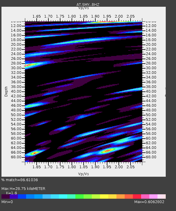
| Estimated Moho Depth: |
28.75 km |
| Estimated Crust Vp/Vs: |
1.60 |
| Assumed Crust Vp: |
3.999 km/s |
| Estimated Crust Vs: |
2.499 km/s |
| Estimated Crust Poisson's Ratio: |
0.18 |
|
| Radial Match: |
86.61036 % |
| Radial Bump: |
400 |
| Transverse Match: |
85.67758 % |
| Transverse Bump: |
370 |
| SOD ConfigId: |
21709731 |
| Insert Time: |
2020-07-02 12:52:49.532 +0000 |
| GWidth: |
2.5 |
| Max Bumps: |
400 |
| Tol: |
0.001 |
|

Signal To Noise
| Channel | StoN | STA | LTA |
| AT:SMY: :BHZ:20200618T13:02:02.479971Z | 60.79321 | 1.2677559E-5 | 2.0853578E-7 |
| AT:SMY: :BHN:20200618T13:02:02.479971Z | 13.749282 | 3.966796E-6 | 2.885093E-7 |
| AT:SMY: :BHE:20200618T13:02:02.479971Z | 3.221614 | 1.052755E-6 | 3.2677877E-7 |
| Arrivals |
| Ps | 4.4 SECOND |
| PpPs | 19 SECOND |
| PsPs/PpSs | 23 SECOND |


