You are here: Home > Network List > AV - Alaska Volcano Observatory Stations List
> Station AHB Akutan Harbor, Akutan Volcano, Alaska > Earthquake Result Viewer
AHB Akutan Harbor, Akutan Volcano, Alaska - Earthquake Result Viewer
| Earthquake location: |
South Of Kermadec Islands |
| Earthquake latitude/longitude: |
-33.3/-177.8 |
| Earthquake time(UTC): |
2020/06/18 (170) 12:49:53 GMT |
| Earthquake Depth: |
10 km |
| Earthquake Magnitude: |
7.4 Mww |
| Earthquake Catalog/Contributor: |
NEIC PDE/us |
|
| Network: |
AV Alaska Volcano Observatory |
| Station: |
AHB Akutan Harbor, Akutan Volcano, Alaska |
| Lat/Lon: |
54.11 N/165.82 W |
| Elevation: |
447 m |
|
| Distance: |
87.7 deg |
| Az: |
7.049 deg |
| Baz: |
190.054 deg |
| Ray Param: |
0.043159205 |
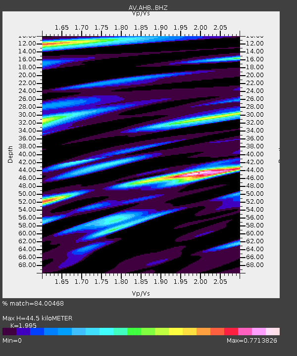
| Estimated Moho Depth: |
44.5 km |
| Estimated Crust Vp/Vs: |
2.00 |
| Assumed Crust Vp: |
5.989 km/s |
| Estimated Crust Vs: |
3.002 km/s |
| Estimated Crust Poisson's Ratio: |
0.33 |
|
| Radial Match: |
84.00468 % |
| Radial Bump: |
400 |
| Transverse Match: |
85.5572 % |
| Transverse Bump: |
400 |
| SOD ConfigId: |
21709731 |
| Insert Time: |
2020-07-02 12:53:32.228 +0000 |
| GWidth: |
2.5 |
| Max Bumps: |
400 |
| Tol: |
0.001 |
|

Signal To Noise
| Channel | StoN | STA | LTA |
| AV:AHB: :BHZ:20200618T13:02:10.819998Z | 9.5946045 | 8.178569E-6 | 8.5241345E-7 |
| AV:AHB: :BHN:20200618T13:02:10.819998Z | 3.6355135 | 3.2778917E-6 | 9.01631E-7 |
| AV:AHB: :BHE:20200618T13:02:10.819998Z | 1.598745 | 1.1801435E-6 | 7.3816875E-7 |
| Arrivals |
| Ps | 7.5 SECOND |
| PpPs | 22 SECOND |
| PsPs/PpSs | 29 SECOND |


