You are here: Home > Network List > AV - Alaska Volcano Observatory Stations List
> Station AKBB Akutan Broiad Bright, Akutan Volcano, Alaska > Earthquake Result Viewer
AKBB Akutan Broiad Bright, Akutan Volcano, Alaska - Earthquake Result Viewer
| Earthquake location: |
South Of Kermadec Islands |
| Earthquake latitude/longitude: |
-33.3/-177.8 |
| Earthquake time(UTC): |
2020/06/18 (170) 12:49:53 GMT |
| Earthquake Depth: |
10 km |
| Earthquake Magnitude: |
7.4 Mww |
| Earthquake Catalog/Contributor: |
NEIC PDE/us |
|
| Network: |
AV Alaska Volcano Observatory |
| Station: |
AKBB Akutan Broiad Bright, Akutan Volcano, Alaska |
| Lat/Lon: |
54.10 N/165.93 W |
| Elevation: |
310 m |
|
| Distance: |
87.6 deg |
| Az: |
6.985 deg |
| Baz: |
189.958 deg |
| Ray Param: |
0.043180127 |
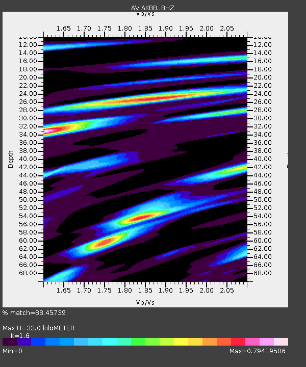
| Estimated Moho Depth: |
33.0 km |
| Estimated Crust Vp/Vs: |
1.60 |
| Assumed Crust Vp: |
5.989 km/s |
| Estimated Crust Vs: |
3.743 km/s |
| Estimated Crust Poisson's Ratio: |
0.18 |
|
| Radial Match: |
88.45739 % |
| Radial Bump: |
400 |
| Transverse Match: |
81.270645 % |
| Transverse Bump: |
400 |
| SOD ConfigId: |
21709731 |
| Insert Time: |
2020-07-02 12:53:32.675 +0000 |
| GWidth: |
2.5 |
| Max Bumps: |
400 |
| Tol: |
0.001 |
|

Signal To Noise
| Channel | StoN | STA | LTA |
| AV:AKBB: :BHZ:20200618T13:02:10.679983Z | 15.641264 | 6.971889E-6 | 4.4573693E-7 |
| AV:AKBB: :BHN:20200618T13:02:10.679983Z | 5.01525 | 3.0336857E-6 | 6.0489225E-7 |
| AV:AKBB: :BHE:20200618T13:02:10.679983Z | 1.479476 | 6.862073E-7 | 4.6381777E-7 |
| Arrivals |
| Ps | 3.4 SECOND |
| PpPs | 14 SECOND |
| PsPs/PpSs | 17 SECOND |


