You are here: Home > Network List > AV - Alaska Volcano Observatory Stations List
> Station AUJK Augustine Jurgen Kienle, Cook Inlet, Alaska > Earthquake Result Viewer
AUJK Augustine Jurgen Kienle, Cook Inlet, Alaska - Earthquake Result Viewer
| Earthquake location: |
South Of Kermadec Islands |
| Earthquake latitude/longitude: |
-33.3/-177.8 |
| Earthquake time(UTC): |
2020/06/18 (170) 12:49:53 GMT |
| Earthquake Depth: |
10 km |
| Earthquake Magnitude: |
7.4 Mww |
| Earthquake Catalog/Contributor: |
NEIC PDE/us |
|
| Network: |
AV Alaska Volcano Observatory |
| Station: |
AUJK Augustine Jurgen Kienle, Cook Inlet, Alaska |
| Lat/Lon: |
59.35 N/153.41 W |
| Elevation: |
377 m |
|
| Distance: |
94.5 deg |
| Az: |
12.271 deg |
| Baz: |
200.331 deg |
| Ray Param: |
0.04102891 |
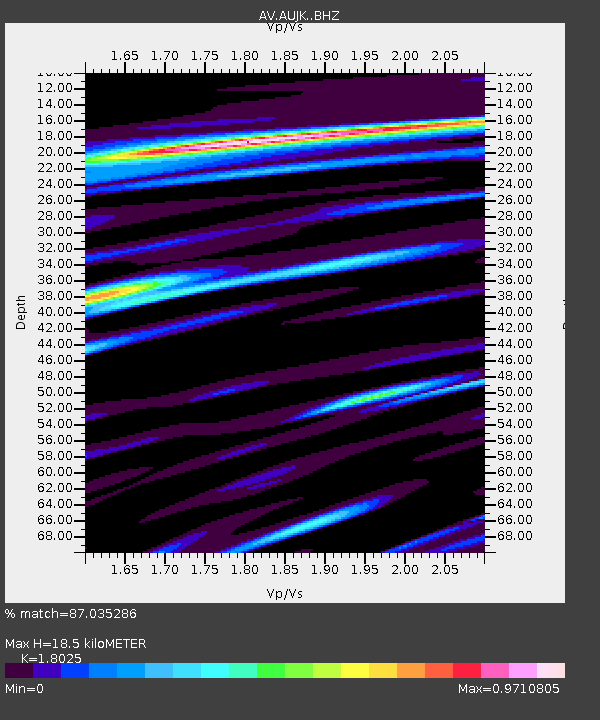
| Estimated Moho Depth: |
18.5 km |
| Estimated Crust Vp/Vs: |
1.80 |
| Assumed Crust Vp: |
5.989 km/s |
| Estimated Crust Vs: |
3.323 km/s |
| Estimated Crust Poisson's Ratio: |
0.28 |
|
| Radial Match: |
87.035286 % |
| Radial Bump: |
400 |
| Transverse Match: |
68.454895 % |
| Transverse Bump: |
400 |
| SOD ConfigId: |
21709731 |
| Insert Time: |
2020-07-02 12:53:48.115 +0000 |
| GWidth: |
2.5 |
| Max Bumps: |
400 |
| Tol: |
0.001 |
|

Signal To Noise
| Channel | StoN | STA | LTA |
| AV:AUJK: :BHZ:20200618T13:02:42.479971Z | 7.612225 | 4.198037E-6 | 5.514862E-7 |
| AV:AUJK: :BHN:20200618T13:02:42.479971Z | 1.2321202 | 1.5604595E-6 | 1.2664833E-6 |
| AV:AUJK: :BHE:20200618T13:02:42.479971Z | 0.93887955 | 9.018149E-7 | 9.605225E-7 |
| Arrivals |
| Ps | 2.5 SECOND |
| PpPs | 8.5 SECOND |
| PsPs/PpSs | 11 SECOND |


