You are here: Home > Network List > AV - Alaska Volcano Observatory Stations List
> Station GSCK Cape Kiugilak, Great Sitkin Volcano, Alaska > Earthquake Result Viewer
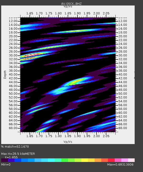
GSCK Cape Kiugilak, Great Sitkin Volcano, Alaska - Earthquake Result Viewer
| Earthquake location: |
South Of Kermadec Islands |
| Earthquake latitude/longitude: |
-33.3/-177.8 |
| Earthquake time(UTC): |
2020/06/18 (170) 12:49:53 GMT |
| Earthquake Depth: |
10 km |
| Earthquake Magnitude: |
7.4 Mww |
| Earthquake Catalog/Contributor: |
NEIC PDE/us |
|
| Network: |
AV Alaska Volcano Observatory |
| Station: |
GSCK Cape Kiugilak, Great Sitkin Volcano, Alaska |
| Lat/Lon: |
52.01 N/176.16 W |
| Elevation: |
384 m |
|
| Distance: |
85.0 deg |
| Az: |
1.039 deg |
| Baz: |
181.408 deg |
| Ray Param: |
0.045117248 |
| Estimated Moho Depth: |
29.5 km |
| Estimated Crust Vp/Vs: |
1.65 |
| Assumed Crust Vp: |
3.912 km/s |
| Estimated Crust Vs: |
2.364 km/s |
| Estimated Crust Poisson's Ratio: |
0.21 |
|
| Radial Match: |
82.1678 % |
| Radial Bump: |
400 |
| Transverse Match: |
83.4661 % |
| Transverse Bump: |
400 |
| SOD ConfigId: |
21709731 |
| Insert Time: |
2020-07-02 12:54:16.107 +0000 |
| GWidth: |
2.5 |
| Max Bumps: |
400 |
| Tol: |
0.001 |
|

Signal To Noise
| Channel | StoN | STA | LTA |
| AV:GSCK: :BHZ:20200618T13:01:57.52001Z | 40.58829 | 8.929844E-6 | 2.2001035E-7 |
| AV:GSCK: :BHN:20200618T13:01:57.52001Z | 12.050093 | 2.935035E-6 | 2.4356947E-7 |
| AV:GSCK: :BHE:20200618T13:01:57.52001Z | 1.4718809 | 4.7523352E-7 | 3.2287497E-7 |
| Arrivals |
| Ps | 5.0 SECOND |
| PpPs | 20 SECOND |
| PsPs/PpSs | 25 SECOND |


