You are here: Home > Network List > AV - Alaska Volcano Observatory Stations List
> Station GSIG Igitkin Island, Great Sitkin Volcano, Alaska > Earthquake Result Viewer
GSIG Igitkin Island, Great Sitkin Volcano, Alaska - Earthquake Result Viewer
| Earthquake location: |
South Of Kermadec Islands |
| Earthquake latitude/longitude: |
-33.3/-177.8 |
| Earthquake time(UTC): |
2020/06/18 (170) 12:49:53 GMT |
| Earthquake Depth: |
10 km |
| Earthquake Magnitude: |
7.4 Mww |
| Earthquake Catalog/Contributor: |
NEIC PDE/us |
|
| Network: |
AV Alaska Volcano Observatory |
| Station: |
GSIG Igitkin Island, Great Sitkin Volcano, Alaska |
| Lat/Lon: |
51.99 N/175.93 W |
| Elevation: |
407 m |
|
| Distance: |
84.9 deg |
| Az: |
1.187 deg |
| Baz: |
181.607 deg |
| Ray Param: |
0.045132954 |
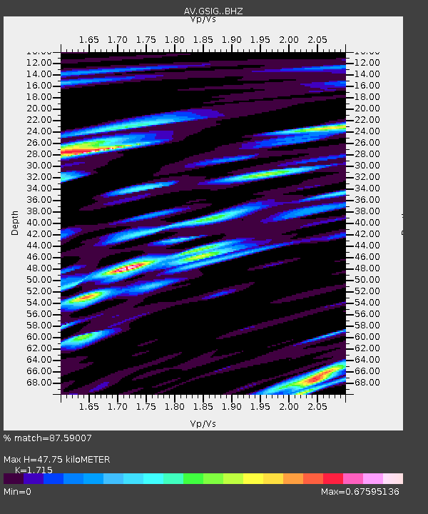
| Estimated Moho Depth: |
47.75 km |
| Estimated Crust Vp/Vs: |
1.72 |
| Assumed Crust Vp: |
3.943 km/s |
| Estimated Crust Vs: |
2.299 km/s |
| Estimated Crust Poisson's Ratio: |
0.24 |
|
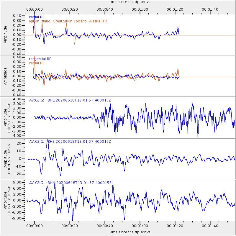
| Radial Match: |
87.59007 % |
| Radial Bump: |
400 |
| Transverse Match: |
86.40068 % |
| Transverse Bump: |
400 |
| SOD ConfigId: |
21709731 |
| Insert Time: |
2020-07-02 12:54:16.477 +0000 |
| GWidth: |
2.5 |
| Max Bumps: |
400 |
| Tol: |
0.001 |
|
Signal To Noise
| Channel | StoN | STA | LTA |
| AV:GSIG: :BHZ:20200618T13:01:57.400015Z | 53.390785 | 8.149122E-6 | 1.5263161E-7 |
| AV:GSIG: :BHN:20200618T13:01:57.400015Z | 16.076984 | 2.781715E-6 | 1.7302467E-7 |
| AV:GSIG: :BHE:20200618T13:01:57.400015Z | 1.4084275 | 2.874372E-7 | 2.0408376E-7 |
| Arrivals |
| Ps | 8.7 SECOND |
| PpPs | 33 SECOND |
| PsPs/PpSs | 41 SECOND |


