You are here: Home > Network List > AV - Alaska Volcano Observatory Stations List
> Station KIWB Westway Bight, Kanaga Volcano, Alaska > Earthquake Result Viewer
KIWB Westway Bight, Kanaga Volcano, Alaska - Earthquake Result Viewer
| Earthquake location: |
South Of Kermadec Islands |
| Earthquake latitude/longitude: |
-33.3/-177.8 |
| Earthquake time(UTC): |
2020/06/18 (170) 12:49:53 GMT |
| Earthquake Depth: |
10 km |
| Earthquake Magnitude: |
7.4 Mww |
| Earthquake Catalog/Contributor: |
NEIC PDE/us |
|
| Network: |
AV Alaska Volcano Observatory |
| Station: |
KIWB Westway Bight, Kanaga Volcano, Alaska |
| Lat/Lon: |
51.85 N/177.15 W |
| Elevation: |
244 m |
|
| Distance: |
84.8 deg |
| Az: |
0.427 deg |
| Baz: |
180.577 deg |
| Ray Param: |
0.045239765 |
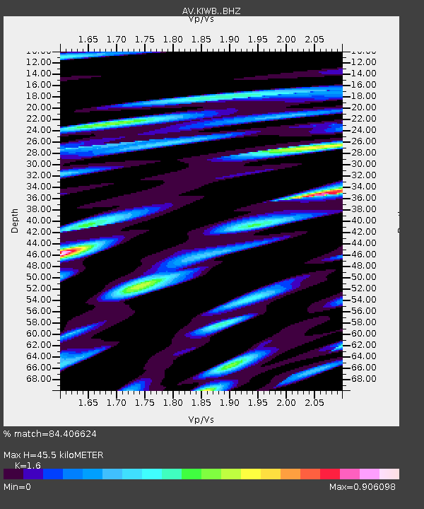
| Estimated Moho Depth: |
45.5 km |
| Estimated Crust Vp/Vs: |
1.60 |
| Assumed Crust Vp: |
5.88 km/s |
| Estimated Crust Vs: |
3.675 km/s |
| Estimated Crust Poisson's Ratio: |
0.18 |
|
| Radial Match: |
84.406624 % |
| Radial Bump: |
400 |
| Transverse Match: |
83.89694 % |
| Transverse Bump: |
400 |
| SOD ConfigId: |
21709731 |
| Insert Time: |
2020-07-02 12:54:44.984 +0000 |
| GWidth: |
2.5 |
| Max Bumps: |
400 |
| Tol: |
0.001 |
|
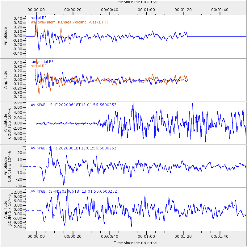
Signal To Noise
| Channel | StoN | STA | LTA |
| AV:KIWB: :BHZ:20200618T13:01:56.660025Z | 59.514 | 8.454507E-6 | 1.4205915E-7 |
| AV:KIWB: :BHN:20200618T13:01:56.660025Z | 15.557152 | 3.14078E-6 | 2.0188658E-7 |
| AV:KIWB: :BHE:20200618T13:01:56.660025Z | 2.1599948 | 4.2440684E-7 | 1.9648512E-7 |
| Arrivals |
| Ps | 4.7 SECOND |
| PpPs | 20 SECOND |
| PsPs/PpSs | 24 SECOND |


