You are here: Home > Network List > AV - Alaska Volcano Observatory Stations List
> Station KOFP Flat Point, Korovin Volcano, Alaska > Earthquake Result Viewer
KOFP Flat Point, Korovin Volcano, Alaska - Earthquake Result Viewer
| Earthquake location: |
South Of Kermadec Islands |
| Earthquake latitude/longitude: |
-33.3/-177.8 |
| Earthquake time(UTC): |
2020/06/18 (170) 12:49:53 GMT |
| Earthquake Depth: |
10 km |
| Earthquake Magnitude: |
7.4 Mww |
| Earthquake Catalog/Contributor: |
NEIC PDE/us |
|
| Network: |
AV Alaska Volcano Observatory |
| Station: |
KOFP Flat Point, Korovin Volcano, Alaska |
| Lat/Lon: |
52.27 N/174.10 W |
| Elevation: |
662 m |
|
| Distance: |
85.3 deg |
| Az: |
2.304 deg |
| Baz: |
183.142 deg |
| Ray Param: |
0.04488844 |
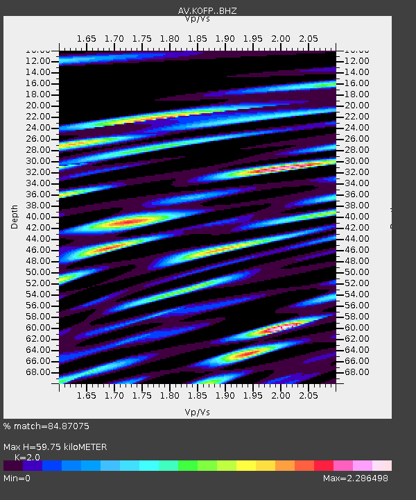
| Estimated Moho Depth: |
59.75 km |
| Estimated Crust Vp/Vs: |
2.00 |
| Assumed Crust Vp: |
5.88 km/s |
| Estimated Crust Vs: |
2.94 km/s |
| Estimated Crust Poisson's Ratio: |
0.33 |
|
| Radial Match: |
84.87075 % |
| Radial Bump: |
400 |
| Transverse Match: |
79.15014 % |
| Transverse Bump: |
400 |
| SOD ConfigId: |
21709731 |
| Insert Time: |
2020-07-02 12:54:45.674 +0000 |
| GWidth: |
2.5 |
| Max Bumps: |
400 |
| Tol: |
0.001 |
|

Signal To Noise
| Channel | StoN | STA | LTA |
| AV:KOFP: :BHZ:20200618T13:01:59.07897Z | 18.503897 | 8.97098E-6 | 4.848157E-7 |
| AV:KOFP: :BHN:20200618T13:01:59.07897Z | 2.3989162 | 3.945619E-6 | 1.6447506E-6 |
| AV:KOFP: :BHE:20200618T13:01:59.07897Z | 0.55918163 | 8.403232E-7 | 1.5027732E-6 |
| Arrivals |
| Ps | 10 SECOND |
| PpPs | 30 SECOND |
| PsPs/PpSs | 40 SECOND |


