You are here: Home > Network List > AV - Alaska Volcano Observatory Stations List
> Station KOKV Korovin Volcano, Korovin Volcano, Alaska > Earthquake Result Viewer
KOKV Korovin Volcano, Korovin Volcano, Alaska - Earthquake Result Viewer
| Earthquake location: |
South Of Kermadec Islands |
| Earthquake latitude/longitude: |
-33.3/-177.8 |
| Earthquake time(UTC): |
2020/06/18 (170) 12:49:53 GMT |
| Earthquake Depth: |
10 km |
| Earthquake Magnitude: |
7.4 Mww |
| Earthquake Catalog/Contributor: |
NEIC PDE/us |
|
| Network: |
AV Alaska Volcano Observatory |
| Station: |
KOKV Korovin Volcano, Korovin Volcano, Alaska |
| Lat/Lon: |
52.36 N/174.17 W |
| Elevation: |
776 m |
|
| Distance: |
85.4 deg |
| Az: |
2.258 deg |
| Baz: |
183.084 deg |
| Ray Param: |
0.044826824 |
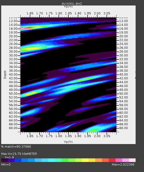
| Estimated Moho Depth: |
15.75 km |
| Estimated Crust Vp/Vs: |
1.60 |
| Assumed Crust Vp: |
5.88 km/s |
| Estimated Crust Vs: |
3.675 km/s |
| Estimated Crust Poisson's Ratio: |
0.18 |
|
| Radial Match: |
90.37868 % |
| Radial Bump: |
400 |
| Transverse Match: |
82.84625 % |
| Transverse Bump: |
400 |
| SOD ConfigId: |
21709731 |
| Insert Time: |
2020-07-02 12:54:48.450 +0000 |
| GWidth: |
2.5 |
| Max Bumps: |
400 |
| Tol: |
0.001 |
|

Signal To Noise
| Channel | StoN | STA | LTA |
| AV:KOKV: :BHZ:20200618T13:01:59.499014Z | 16.126934 | 7.0786623E-6 | 4.3893417E-7 |
| AV:KOKV: :BHN:20200618T13:01:59.499014Z | 2.1001635 | 1.5410853E-6 | 7.3379306E-7 |
| AV:KOKV: :BHE:20200618T13:01:59.499014Z | 1.5577923 | 1.2113425E-6 | 7.77602E-7 |
| Arrivals |
| Ps | 1.6 SECOND |
| PpPs | 6.8 SECOND |
| PsPs/PpSs | 8.5 SECOND |


