You are here: Home > Network List > AV - Alaska Volcano Observatory Stations List
> Station SPCR Ckakachatna River, Mount Spurr, Alaska > Earthquake Result Viewer
SPCR Ckakachatna River, Mount Spurr, Alaska - Earthquake Result Viewer

| Earthquake location: |
South Of Kermadec Islands |
| Earthquake latitude/longitude: |
-33.3/-177.8 |
| Earthquake time(UTC): |
2020/06/18 (170) 12:49:53 GMT |
| Earthquake Depth: |
10 km |
| Earthquake Magnitude: |
7.4 Mww |
| Earthquake Catalog/Contributor: |
NEIC PDE/us |
|
| Network: |
AV Alaska Volcano Observatory |
| Station: |
SPCR Ckakachatna River, Mount Spurr, Alaska |
| Lat/Lon: |
61.20 N/152.21 W |
| Elevation: |
984 m |
|
| Distance: |
96.5 deg |
| Az: |
12.169 deg |
| Baz: |
201.382 deg |
| Ray Param: |
0.04051245 |
| Estimated Moho Depth: |
29.25 km |
| Estimated Crust Vp/Vs: |
1.63 |
| Assumed Crust Vp: |
6.566 km/s |
| Estimated Crust Vs: |
4.016 km/s |
| Estimated Crust Poisson's Ratio: |
0.20 |
|
| Radial Match: |
85.582886 % |
| Radial Bump: |
400 |
| Transverse Match: |
79.12304 % |
| Transverse Bump: |
400 |
| SOD ConfigId: |
21709731 |
| Insert Time: |
2020-07-02 12:55:24.249 +0000 |
| GWidth: |
2.5 |
| Max Bumps: |
400 |
| Tol: |
0.001 |
|
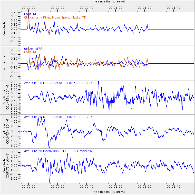
Signal To Noise
| Channel | StoN | STA | LTA |
| AV:SPCR: :BHZ:20200618T13:02:51.299979Z | 11.694541 | 2.224066E-6 | 1.9017985E-7 |
| AV:SPCR: :BHN:20200618T13:02:51.299979Z | 2.5230432 | 6.1127304E-7 | 2.422761E-7 |
| AV:SPCR: :BHE:20200618T13:02:51.299979Z | 0.9334754 | 3.1337686E-7 | 3.3570984E-7 |
| Arrivals |
| Ps | 2.9 SECOND |
| PpPs | 11 SECOND |
| PsPs/PpSs | 14 SECOND |


