You are here: Home > Network List > AV - Alaska Volcano Observatory Stations List
> Station TAPA Point Aries, Tanaga Volcano, Alaska > Earthquake Result Viewer
TAPA Point Aries, Tanaga Volcano, Alaska - Earthquake Result Viewer
| Earthquake location: |
South Of Kermadec Islands |
| Earthquake latitude/longitude: |
-33.3/-177.8 |
| Earthquake time(UTC): |
2020/06/18 (170) 12:49:53 GMT |
| Earthquake Depth: |
10 km |
| Earthquake Magnitude: |
7.4 Mww |
| Earthquake Catalog/Contributor: |
NEIC PDE/us |
|
| Network: |
AV Alaska Volcano Observatory |
| Station: |
TAPA Point Aries, Tanaga Volcano, Alaska |
| Lat/Lon: |
51.81 N/177.81 W |
| Elevation: |
640 m |
|
| Distance: |
84.7 deg |
| Az: |
0.015 deg |
| Baz: |
180.02 deg |
| Ray Param: |
0.04526838 |
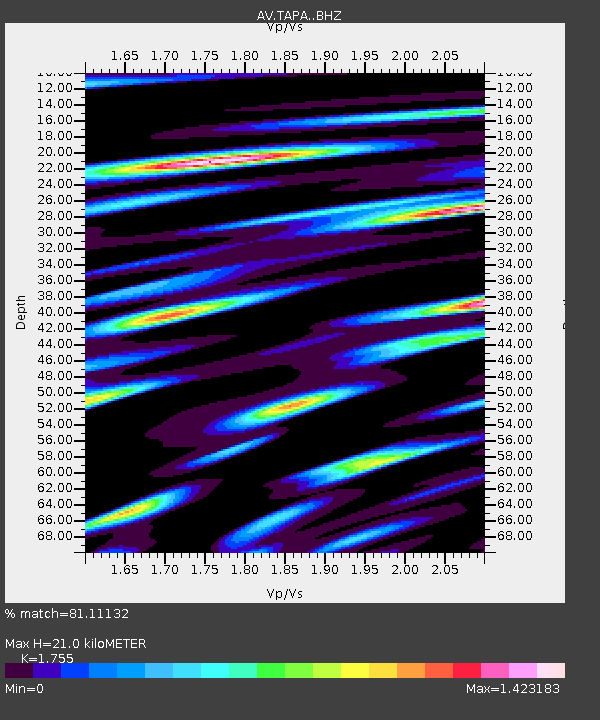
| Estimated Moho Depth: |
21.0 km |
| Estimated Crust Vp/Vs: |
1.75 |
| Assumed Crust Vp: |
5.88 km/s |
| Estimated Crust Vs: |
3.351 km/s |
| Estimated Crust Poisson's Ratio: |
0.26 |
|
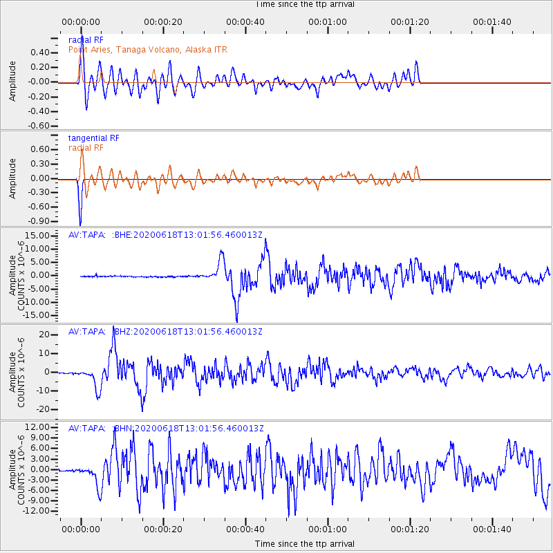
| Radial Match: |
81.11132 % |
| Radial Bump: |
400 |
| Transverse Match: |
99.93845 % |
| Transverse Bump: |
17 |
| SOD ConfigId: |
21709731 |
| Insert Time: |
2020-07-02 12:55:33.586 +0000 |
| GWidth: |
2.5 |
| Max Bumps: |
400 |
| Tol: |
0.001 |
|
Signal To Noise
| Channel | StoN | STA | LTA |
| AV:TAPA: :BHZ:20200618T13:01:56.460013Z | 27.022886 | 5.878029E-6 | 2.1752041E-7 |
| AV:TAPA: :BHN:20200618T13:01:56.460013Z | 5.413792 | 3.1527177E-6 | 5.8234923E-7 |
| AV:TAPA: :BHE:20200618T13:01:56.460013Z | 23.663918 | 4.1013177E-6 | 1.7331524E-7 |
| Arrivals |
| Ps | 2.8 SECOND |
| PpPs | 9.6 SECOND |
| PsPs/PpSs | 12 SECOND |


