You are here: Home > Network List > AV - Alaska Volcano Observatory Stations List
> Station R17L Mt. Peulik Volcano, AVO PLK4, AK, USA > Earthquake Result Viewer
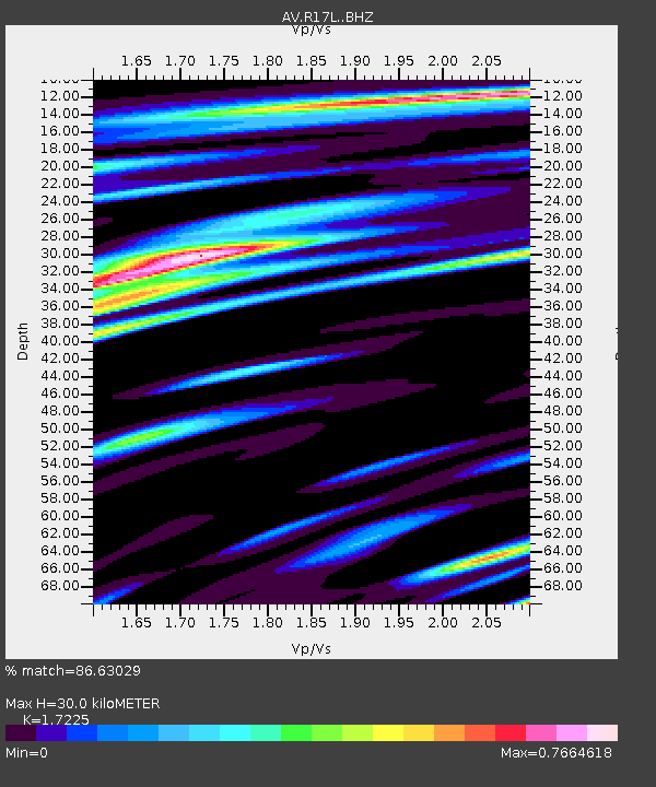
R17L Mt. Peulik Volcano, AVO PLK4, AK, USA - Earthquake Result Viewer
| Earthquake location: |
South Of Kermadec Islands |
| Earthquake latitude/longitude: |
-33.3/-177.8 |
| Earthquake time(UTC): |
2020/06/18 (170) 12:49:53 GMT |
| Earthquake Depth: |
10 km |
| Earthquake Magnitude: |
7.4 Mww |
| Earthquake Catalog/Contributor: |
NEIC PDE/us |
|
| Network: |
AV Alaska Volcano Observatory |
| Station: |
R17L Mt. Peulik Volcano, AVO PLK4, AK, USA |
| Lat/Lon: |
57.63 N/156.36 W |
| Elevation: |
524 m |
|
| Distance: |
92.4 deg |
| Az: |
11.369 deg |
| Baz: |
197.874 deg |
| Ray Param: |
0.041470222 |
| Estimated Moho Depth: |
30.0 km |
| Estimated Crust Vp/Vs: |
1.72 |
| Assumed Crust Vp: |
6.1 km/s |
| Estimated Crust Vs: |
3.541 km/s |
| Estimated Crust Poisson's Ratio: |
0.25 |
|
| Radial Match: |
86.63029 % |
| Radial Bump: |
400 |
| Transverse Match: |
74.07857 % |
| Transverse Bump: |
400 |
| SOD ConfigId: |
21709731 |
| Insert Time: |
2020-07-02 12:55:49.157 +0000 |
| GWidth: |
2.5 |
| Max Bumps: |
400 |
| Tol: |
0.001 |
|

Signal To Noise
| Channel | StoN | STA | LTA |
| AV:R17L: :BHZ:20200618T13:02:32.700003Z | 11.519872 | 5.284989E-6 | 4.5877155E-7 |
| AV:R17L: :BHN:20200618T13:02:32.700003Z | 2.2715988 | 1.1917392E-6 | 5.2462576E-7 |
| AV:R17L: :BHE:20200618T13:02:32.700003Z | 0.87167376 | 3.4595223E-7 | 3.9688268E-7 |
| Arrivals |
| Ps | 3.6 SECOND |
| PpPs | 13 SECOND |
| PsPs/PpSs | 17 SECOND |


