You are here: Home > Network List > WI - West Indies IPGP Network Stations List
> Station MPOM Morne Pois, Sainte-Anne, Martinique > Earthquake Result Viewer
MPOM Morne Pois, Sainte-Anne, Martinique - Earthquake Result Viewer
| Earthquake location: |
Near Coast Of Chiapas, Mexico |
| Earthquake latitude/longitude: |
14.9/-92.0 |
| Earthquake time(UTC): |
2017/06/14 (165) 07:29:03 GMT |
| Earthquake Depth: |
98 km |
| Earthquake Magnitude: |
7.0 Mi |
| Earthquake Catalog/Contributor: |
NEIC PDE/at |
|
| Network: |
WI West Indies IPGP Network |
| Station: |
MPOM Morne Pois, Sainte-Anne, Martinique |
| Lat/Lon: |
14.45 N/60.86 W |
| Elevation: |
50 m |
|
| Distance: |
30.1 deg |
| Az: |
86.823 deg |
| Baz: |
274.847 deg |
| Ray Param: |
0.07925573 |
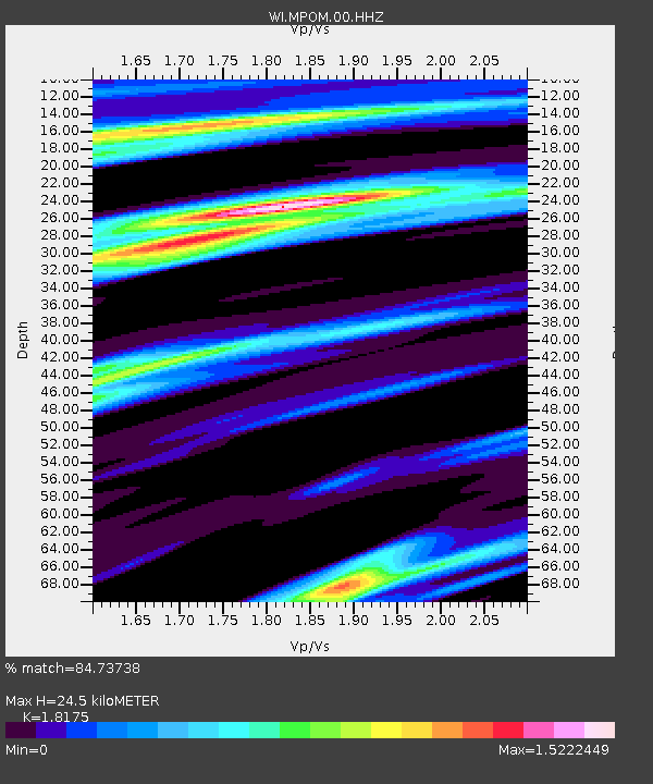
| Estimated Moho Depth: |
24.5 km |
| Estimated Crust Vp/Vs: |
1.82 |
| Assumed Crust Vp: |
5.88 km/s |
| Estimated Crust Vs: |
3.235 km/s |
| Estimated Crust Poisson's Ratio: |
0.28 |
|
| Radial Match: |
84.73738 % |
| Radial Bump: |
400 |
| Transverse Match: |
74.173 % |
| Transverse Bump: |
400 |
| SOD ConfigId: |
2140511 |
| Insert Time: |
2017-06-27 23:25:24.412 +0000 |
| GWidth: |
2.5 |
| Max Bumps: |
400 |
| Tol: |
0.001 |
|

Signal To Noise
| Channel | StoN | STA | LTA |
| WI:MPOM:00:HHZ:20170614T07:34:33.209991Z | 9.557271 | 5.6668755E-6 | 5.9293865E-7 |
| WI:MPOM:00:HHN:20170614T07:34:33.209991Z | 1.89344 | 8.31795E-7 | 4.393036E-7 |
| WI:MPOM:00:HHE:20170614T07:34:33.209991Z | 9.64697 | 4.085827E-6 | 4.2353477E-7 |
| Arrivals |
| Ps | 3.6 SECOND |
| PpPs | 11 SECOND |
| PsPs/PpSs | 15 SECOND |


