You are here: Home > Network List > KN - Kyrgyz Seismic Telemetry Network Stations List
> Station UCH KN.UCH > Earthquake Result Viewer
UCH KN.UCH - Earthquake Result Viewer
*The percent match for this event was below the threshold and hence no stack was calculated.
| Earthquake location: |
Flores Region, Indonesia |
| Earthquake latitude/longitude: |
-8.9/123.5 |
| Earthquake time(UTC): |
1997/01/17 (017) 11:20:22 GMT |
| Earthquake Depth: |
111 km |
| Earthquake Magnitude: |
6.2 MB, 6.2 UNKNOWN, 6.2 MW |
| Earthquake Catalog/Contributor: |
WHDF/NEIC |
|
| Network: |
KN Kyrgyz Seismic Telemetry Network |
| Station: |
UCH KN.UCH |
| Lat/Lon: |
42.23 N/74.51 E |
| Elevation: |
3850 m |
|
| Distance: |
67.8 deg |
| Az: |
322.713 deg |
| Baz: |
126.297 deg |
| Ray Param: |
$rayparam |
*The percent match for this event was below the threshold and hence was not used in the summary stack. |
|
| Radial Match: |
100.0 % |
| Radial Bump: |
2 |
| Transverse Match: |
100.00001 % |
| Transverse Bump: |
2 |
| SOD ConfigId: |
4480 |
| Insert Time: |
2010-03-08 21:33:12.846 +0000 |
| GWidth: |
2.5 |
| Max Bumps: |
400 |
| Tol: |
0.001 |
|
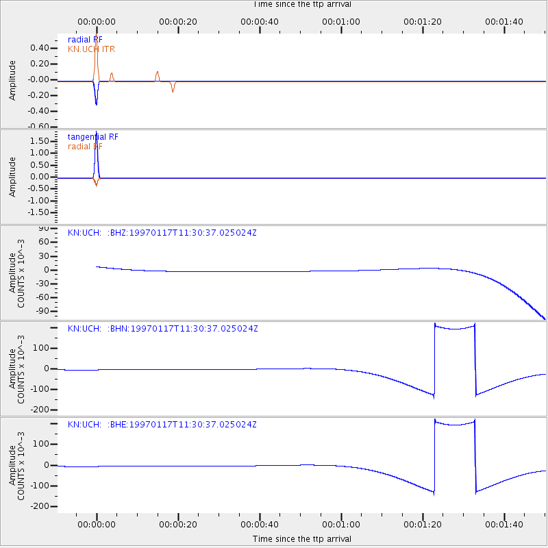
Signal To Noise
| Channel | StoN | STA | LTA |
| KN:UCH: :BHN:19970117T11:30:37.025024Z | 0.9484335 | 0.002859463 | 0.0030149324 |
| KN:UCH: :BHE:19970117T11:30:37.025024Z | 0.94869584 | 0.0028602444 | 0.0030149224 |
| KN:UCH: :BHZ:19970117T11:30:37.025024Z | 0.948831 | 0.0028606122 | 0.0030148805 |
| Arrivals |
| Ps | |
| PpPs | |
| PsPs/PpSs | |


