You are here: Home > Network List > C1 - Red Sismologica Nacional Stations List
> Station MT12 Pirque > Earthquake Result Viewer
MT12 Pirque - Earthquake Result Viewer
| Earthquake location: |
South Of Kermadec Islands |
| Earthquake latitude/longitude: |
-33.3/-177.8 |
| Earthquake time(UTC): |
2020/06/18 (170) 12:49:53 GMT |
| Earthquake Depth: |
10 km |
| Earthquake Magnitude: |
7.4 Mww |
| Earthquake Catalog/Contributor: |
NEIC PDE/us |
|
| Network: |
C1 Red Sismologica Nacional |
| Station: |
MT12 Pirque |
| Lat/Lon: |
33.73 S/70.55 W |
| Elevation: |
727 m |
|
| Distance: |
84.6 deg |
| Az: |
126.939 deg |
| Baz: |
233.447 deg |
| Ray Param: |
0.045390155 |
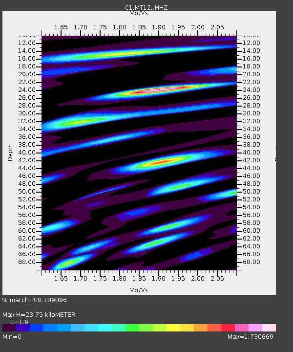
| Estimated Moho Depth: |
23.75 km |
| Estimated Crust Vp/Vs: |
1.90 |
| Assumed Crust Vp: |
6.481 km/s |
| Estimated Crust Vs: |
3.411 km/s |
| Estimated Crust Poisson's Ratio: |
0.31 |
|
| Radial Match: |
89.189896 % |
| Radial Bump: |
400 |
| Transverse Match: |
81.50067 % |
| Transverse Bump: |
400 |
| SOD ConfigId: |
21709731 |
| Insert Time: |
2020-07-02 12:57:58.398 +0000 |
| GWidth: |
2.5 |
| Max Bumps: |
400 |
| Tol: |
0.001 |
|

Signal To Noise
| Channel | StoN | STA | LTA |
| C1:MT12: :HHZ:20200618T13:01:55.608023Z | 13.633156 | 6.2451277E-6 | 4.580838E-7 |
| C1:MT12: :HHN:20200618T13:01:55.608023Z | 4.352976 | 1.5383049E-6 | 3.5339156E-7 |
| C1:MT12: :HHE:20200618T13:01:55.608023Z | 6.220368 | 2.0576076E-6 | 3.3078553E-7 |
| Arrivals |
| Ps | 3.4 SECOND |
| PpPs | 10 SECOND |
| PsPs/PpSs | 14 SECOND |


