You are here: Home > Network List > CC - Cascade Chain Volcano Monitoring Stations List
> Station TCBU Trout Creek Butte at 3-Sisters, OR > Earthquake Result Viewer
TCBU Trout Creek Butte at 3-Sisters, OR - Earthquake Result Viewer
| Earthquake location: |
South Of Kermadec Islands |
| Earthquake latitude/longitude: |
-33.3/-177.8 |
| Earthquake time(UTC): |
2020/06/18 (170) 12:49:53 GMT |
| Earthquake Depth: |
10 km |
| Earthquake Magnitude: |
7.4 Mww |
| Earthquake Catalog/Contributor: |
NEIC PDE/us |
|
| Network: |
CC Cascade Chain Volcano Monitoring |
| Station: |
TCBU Trout Creek Butte at 3-Sisters, OR |
| Lat/Lon: |
44.24 N/121.66 W |
| Elevation: |
1646 m |
|
| Distance: |
92.6 deg |
| Az: |
36.705 deg |
| Baz: |
224.145 deg |
| Ray Param: |
0.041436374 |
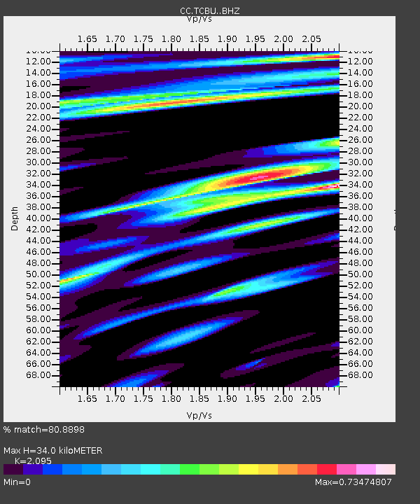
| Estimated Moho Depth: |
34.0 km |
| Estimated Crust Vp/Vs: |
2.10 |
| Assumed Crust Vp: |
6.597 km/s |
| Estimated Crust Vs: |
3.149 km/s |
| Estimated Crust Poisson's Ratio: |
0.35 |
|
| Radial Match: |
80.8898 % |
| Radial Bump: |
400 |
| Transverse Match: |
82.63705 % |
| Transverse Bump: |
400 |
| SOD ConfigId: |
21709731 |
| Insert Time: |
2020-07-02 12:58:59.965 +0000 |
| GWidth: |
2.5 |
| Max Bumps: |
400 |
| Tol: |
0.001 |
|

Signal To Noise
| Channel | StoN | STA | LTA |
| CC:TCBU: :BHZ:20200618T13:02:33.619986Z | 25.920774 | 3.941119E-6 | 1.520448E-7 |
| CC:TCBU: :BHN:20200618T13:02:33.619986Z | 2.2256777 | 5.15601E-7 | 2.3166022E-7 |
| CC:TCBU: :BHE:20200618T13:02:33.619986Z | 1.1413493 | 4.2727788E-7 | 3.7436203E-7 |
| Arrivals |
| Ps | 5.7 SECOND |
| PpPs | 16 SECOND |
| PsPs/PpSs | 21 SECOND |


