You are here: Home > Network List > CI - Caltech Regional Seismic Network Stations List
> Station GLA Glamis, Glamis, CA, USA > Earthquake Result Viewer
GLA Glamis, Glamis, CA, USA - Earthquake Result Viewer
| Earthquake location: |
South Of Kermadec Islands |
| Earthquake latitude/longitude: |
-33.3/-177.8 |
| Earthquake time(UTC): |
2020/06/18 (170) 12:49:53 GMT |
| Earthquake Depth: |
10 km |
| Earthquake Magnitude: |
7.4 Mww |
| Earthquake Catalog/Contributor: |
NEIC PDE/us |
|
| Network: |
CI Caltech Regional Seismic Network |
| Station: |
GLA Glamis, Glamis, CA, USA |
| Lat/Lon: |
33.05 N/114.83 W |
| Elevation: |
610 m |
|
| Distance: |
88.7 deg |
| Az: |
48.467 deg |
| Baz: |
228.291 deg |
| Ray Param: |
0.042390335 |
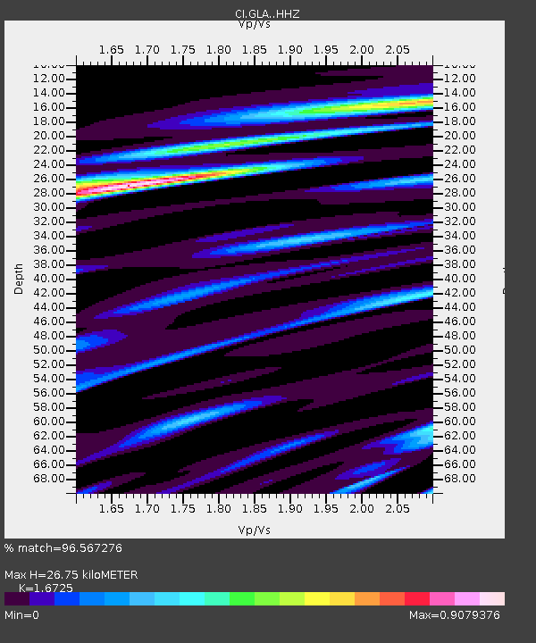
| Estimated Moho Depth: |
26.75 km |
| Estimated Crust Vp/Vs: |
1.67 |
| Assumed Crust Vp: |
6.155 km/s |
| Estimated Crust Vs: |
3.68 km/s |
| Estimated Crust Poisson's Ratio: |
0.22 |
|
| Radial Match: |
96.567276 % |
| Radial Bump: |
325 |
| Transverse Match: |
90.62798 % |
| Transverse Bump: |
400 |
| SOD ConfigId: |
21709731 |
| Insert Time: |
2020-07-02 12:59:41.212 +0000 |
| GWidth: |
2.5 |
| Max Bumps: |
400 |
| Tol: |
0.001 |
|
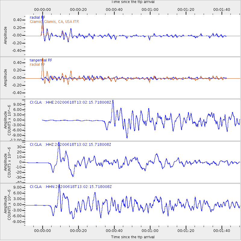
Signal To Noise
| Channel | StoN | STA | LTA |
| CI:GLA: :HHZ:20200618T13:02:15.718008Z | 10.585221 | 1.3587264E-6 | 1.283607E-7 |
| CI:GLA: :HHN:20200618T13:02:15.718008Z | 6.2993717 | 2.9482365E-7 | 4.680207E-8 |
| CI:GLA: :HHE:20200618T13:02:15.718008Z | 2.272832 | 3.2077492E-7 | 1.4113446E-7 |
| Arrivals |
| Ps | 3.0 SECOND |
| PpPs | 11 SECOND |
| PsPs/PpSs | 14 SECOND |


