You are here: Home > Network List > GT - Global Telemetered Seismograph Network (USAF/USGS) Stations List
> Station LPAZ La Paz , Bolivia > Earthquake Result Viewer
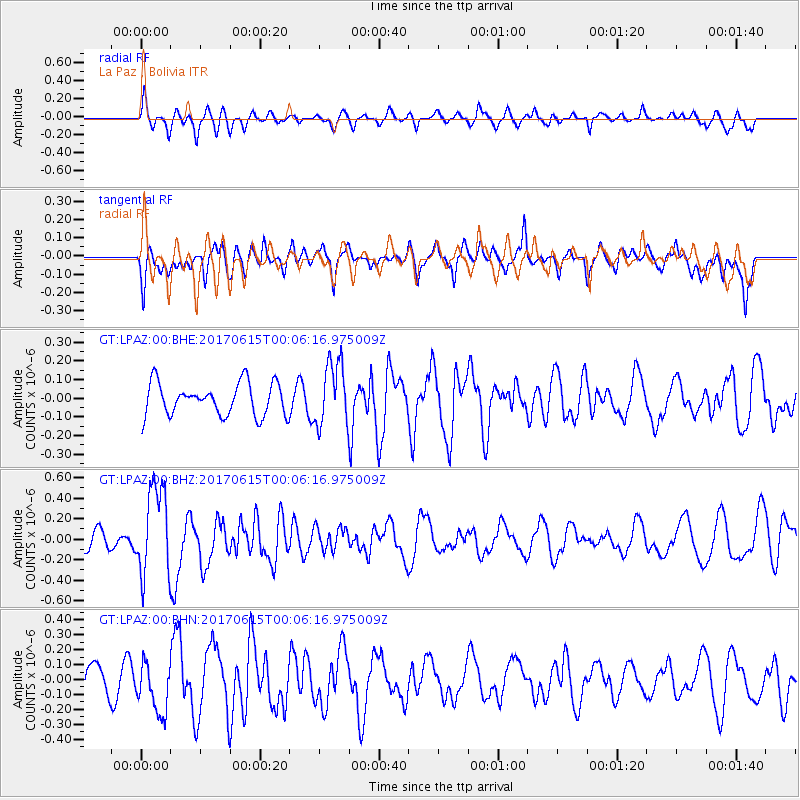
LPAZ La Paz , Bolivia - Earthquake Result Viewer
*The percent match for this event was below the threshold and hence no stack was calculated.
| Earthquake location: |
Near Coast Of Oaxaca, Mexico |
| Earthquake latitude/longitude: |
15.4/-97.1 |
| Earthquake time(UTC): |
2017/06/14 (165) 23:58:52 GMT |
| Earthquake Depth: |
6.9 km |
| Earthquake Magnitude: |
5.5 Mww |
| Earthquake Catalog/Contributor: |
NEIC PDE/us |
|
| Network: |
GT Global Telemetered Seismograph Network (USAF/USGS) |
| Station: |
LPAZ La Paz , Bolivia |
| Lat/Lon: |
16.17 S/68.08 W |
| Elevation: |
4817 m |
|
| Distance: |
42.4 deg |
| Az: |
136.334 deg |
| Baz: |
316.116 deg |
| Ray Param: |
$rayparam |
*The percent match for this event was below the threshold and hence was not used in the summary stack. |
|
| Radial Match: |
64.918236 % |
| Radial Bump: |
400 |
| Transverse Match: |
61.890438 % |
| Transverse Bump: |
400 |
| SOD ConfigId: |
2140511 |
| Insert Time: |
2017-06-28 15:51:15.001 +0000 |
| GWidth: |
2.5 |
| Max Bumps: |
400 |
| Tol: |
0.001 |
|
Signal To Noise
| Channel | StoN | STA | LTA |
| GT:LPAZ:00:BHZ:20170615T00:06:16.975009Z | 3.4751573 | 4.353793E-7 | 1.2528334E-7 |
| GT:LPAZ:00:BHN:20170615T00:06:16.975009Z | 1.1459453 | 1.708384E-7 | 1.4908076E-7 |
| GT:LPAZ:00:BHE:20170615T00:06:16.975009Z | 1.9191811 | 1.64374E-7 | 8.564799E-8 |
| Arrivals |
| Ps | |
| PpPs | |
| PsPs/PpSs | |


