You are here: Home > Network List > CN - Canadian National Seismograph Network Stations List
> Station PNT Penticton, BC, CA > Earthquake Result Viewer
PNT Penticton, BC, CA - Earthquake Result Viewer
| Earthquake location: |
South Of Kermadec Islands |
| Earthquake latitude/longitude: |
-33.3/-177.8 |
| Earthquake time(UTC): |
2020/06/18 (170) 12:49:53 GMT |
| Earthquake Depth: |
10 km |
| Earthquake Magnitude: |
7.4 Mww |
| Earthquake Catalog/Contributor: |
NEIC PDE/us |
|
| Network: |
CN Canadian National Seismograph Network |
| Station: |
PNT Penticton, BC, CA |
| Lat/Lon: |
49.32 N/119.63 W |
| Elevation: |
531 m |
|
| Distance: |
97.2 deg |
| Az: |
34.093 deg |
| Baz: |
225.849 deg |
| Ray Param: |
0.040305473 |
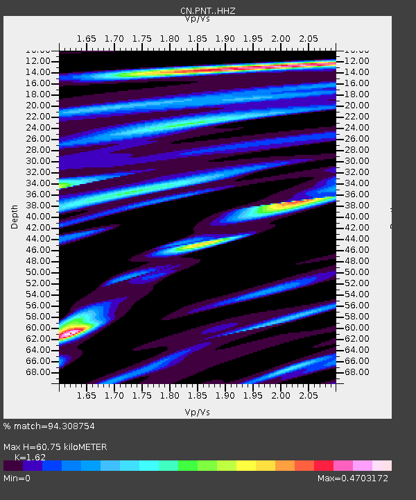
| Estimated Moho Depth: |
60.75 km |
| Estimated Crust Vp/Vs: |
1.62 |
| Assumed Crust Vp: |
6.419 km/s |
| Estimated Crust Vs: |
3.962 km/s |
| Estimated Crust Poisson's Ratio: |
0.19 |
|
| Radial Match: |
94.308754 % |
| Radial Bump: |
400 |
| Transverse Match: |
85.39345 % |
| Transverse Bump: |
400 |
| SOD ConfigId: |
21709731 |
| Insert Time: |
2020-07-02 13:01:35.000 +0000 |
| GWidth: |
2.5 |
| Max Bumps: |
400 |
| Tol: |
0.001 |
|

Signal To Noise
| Channel | StoN | STA | LTA |
| CN:PNT: :HHZ:20200618T13:02:54.429983Z | 37.06703 | 2.0832592E-6 | 5.620248E-8 |
| CN:PNT: :HHN:20200618T13:02:54.429983Z | 10.032864 | 4.46292E-7 | 4.4483013E-8 |
| CN:PNT: :HHE:20200618T13:02:54.429983Z | 12.68461 | 4.448178E-7 | 3.506752E-8 |
| Arrivals |
| Ps | 6.0 SECOND |
| PpPs | 24 SECOND |
| PsPs/PpSs | 30 SECOND |


