You are here: Home > Network List > G - GEOSCOPE Stations List
> Station DRV Dumont d'Urville, Terre Adelie (Antartica) > Earthquake Result Viewer
DRV Dumont d'Urville, Terre Adelie (Antartica) - Earthquake Result Viewer
| Earthquake location: |
South Of Kermadec Islands |
| Earthquake latitude/longitude: |
-33.3/-177.8 |
| Earthquake time(UTC): |
2020/06/18 (170) 12:49:53 GMT |
| Earthquake Depth: |
10 km |
| Earthquake Magnitude: |
7.4 Mww |
| Earthquake Catalog/Contributor: |
NEIC PDE/us |
|
| Network: |
G GEOSCOPE |
| Station: |
DRV Dumont d'Urville, Terre Adelie (Antartica) |
| Lat/Lon: |
66.67 S/140.01 E |
| Elevation: |
40 m |
|
| Distance: |
41.5 deg |
| Az: |
203.774 deg |
| Baz: |
57.951 deg |
| Ray Param: |
0.073729075 |
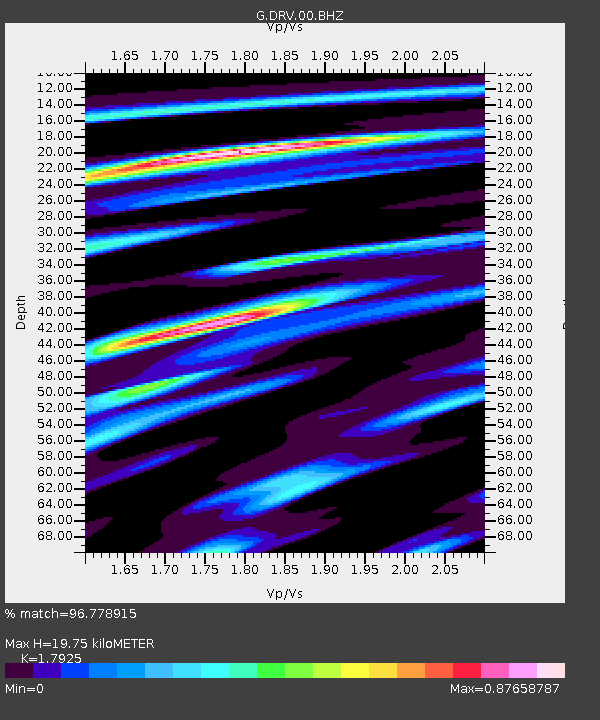
| Estimated Moho Depth: |
19.75 km |
| Estimated Crust Vp/Vs: |
1.79 |
| Assumed Crust Vp: |
6.39 km/s |
| Estimated Crust Vs: |
3.565 km/s |
| Estimated Crust Poisson's Ratio: |
0.27 |
|
| Radial Match: |
96.778915 % |
| Radial Bump: |
316 |
| Transverse Match: |
83.151344 % |
| Transverse Bump: |
400 |
| SOD ConfigId: |
21709731 |
| Insert Time: |
2020-07-02 13:02:05.912 +0000 |
| GWidth: |
2.5 |
| Max Bumps: |
400 |
| Tol: |
0.001 |
|
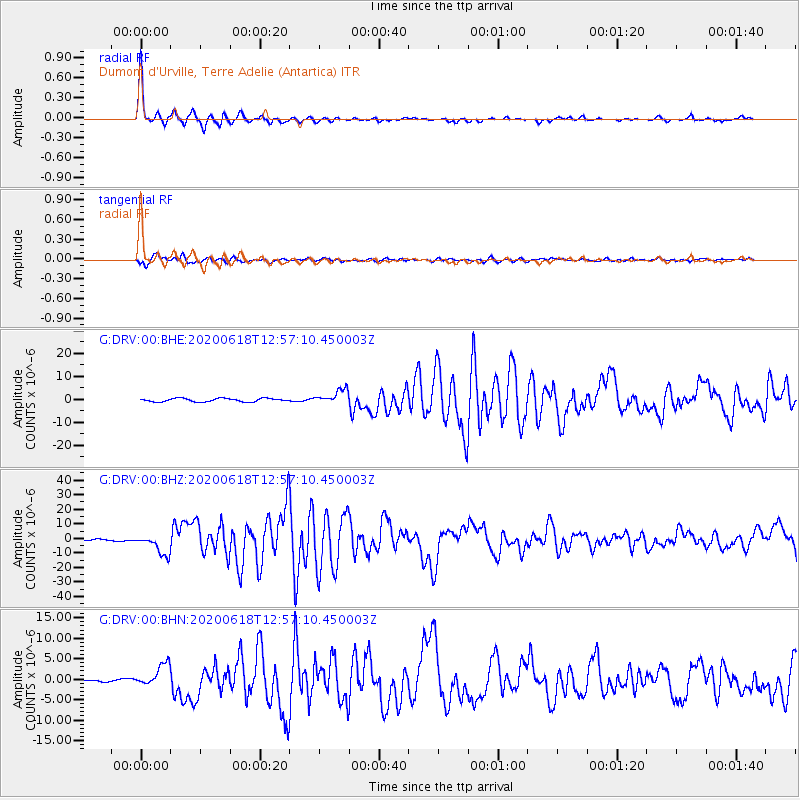
Signal To Noise
| Channel | StoN | STA | LTA |
| G:DRV:00:BHZ:20200618T12:57:10.450003Z | 15.938486 | 6.8564764E-6 | 4.3018363E-7 |
| G:DRV:00:BHN:20200618T12:57:10.450003Z | 4.9537907 | 2.735955E-6 | 5.5229526E-7 |
| G:DRV:00:BHE:20200618T12:57:10.450003Z | 4.273536 | 3.1239E-6 | 7.309871E-7 |
| Arrivals |
| Ps | 2.6 SECOND |
| PpPs | 8.1 SECOND |
| PsPs/PpSs | 11 SECOND |


