You are here: Home > Network List > GS - US Geological Survey Networks Stations List
> Station ALQ2 ASL Reference, STS-6 > Earthquake Result Viewer
ALQ2 ASL Reference, STS-6 - Earthquake Result Viewer
| Earthquake location: |
South Of Kermadec Islands |
| Earthquake latitude/longitude: |
-33.3/-177.8 |
| Earthquake time(UTC): |
2020/06/18 (170) 12:49:53 GMT |
| Earthquake Depth: |
10 km |
| Earthquake Magnitude: |
7.4 Mww |
| Earthquake Catalog/Contributor: |
NEIC PDE/us |
|
| Network: |
GS US Geological Survey Networks |
| Station: |
ALQ2 ASL Reference, STS-6 |
| Lat/Lon: |
34.94 N/106.46 W |
| Elevation: |
1854 m |
|
| Distance: |
95.3 deg |
| Az: |
51.429 deg |
| Baz: |
232.852 deg |
| Ray Param: |
0.04083765 |
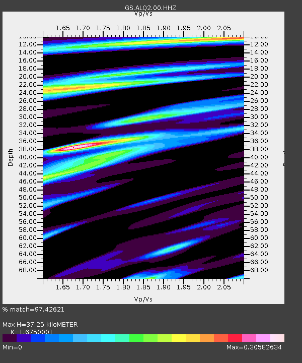
| Estimated Moho Depth: |
37.25 km |
| Estimated Crust Vp/Vs: |
1.68 |
| Assumed Crust Vp: |
6.502 km/s |
| Estimated Crust Vs: |
3.882 km/s |
| Estimated Crust Poisson's Ratio: |
0.22 |
|
| Radial Match: |
97.42621 % |
| Radial Bump: |
385 |
| Transverse Match: |
90.7817 % |
| Transverse Bump: |
400 |
| SOD ConfigId: |
21709731 |
| Insert Time: |
2020-07-02 13:02:25.775 +0000 |
| GWidth: |
2.5 |
| Max Bumps: |
400 |
| Tol: |
0.001 |
|

Signal To Noise
| Channel | StoN | STA | LTA |
| GS:ALQ2:00:HHZ:20200618T13:02:45.957999Z | 20.386541 | 1.3786993E-6 | 6.7627916E-8 |
| GS:ALQ2:00:HH1:20200618T13:02:45.957999Z | 6.7308364 | 2.6400693E-7 | 3.9223494E-8 |
| GS:ALQ2:00:HH2:20200618T13:02:45.957999Z | 7.603291 | 3.2603E-7 | 4.2880114E-8 |
| Arrivals |
| Ps | 4.0 SECOND |
| PpPs | 15 SECOND |
| PsPs/PpSs | 19 SECOND |


