You are here: Home > Network List > IU - Global Seismograph Network (GSN - IRIS/USGS) Stations List
> Station JOHN Johnston Island, USA > Earthquake Result Viewer
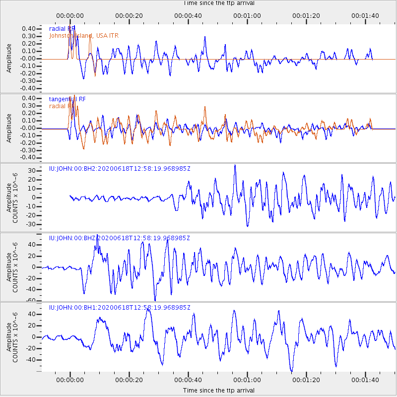
JOHN Johnston Island, USA - Earthquake Result Viewer
*The percent match for this event was below the threshold and hence no stack was calculated.
| Earthquake location: |
South Of Kermadec Islands |
| Earthquake latitude/longitude: |
-33.3/-177.8 |
| Earthquake time(UTC): |
2020/06/18 (170) 12:49:53 GMT |
| Earthquake Depth: |
10 km |
| Earthquake Magnitude: |
7.4 Mww |
| Earthquake Catalog/Contributor: |
NEIC PDE/us |
|
| Network: |
IU Global Seismograph Network (GSN - IRIS/USGS) |
| Station: |
JOHN Johnston Island, USA |
| Lat/Lon: |
16.73 N/169.53 W |
| Elevation: |
2.0 m |
|
| Distance: |
50.4 deg |
| Az: |
10.357 deg |
| Baz: |
189.041 deg |
| Ray Param: |
$rayparam |
*The percent match for this event was below the threshold and hence was not used in the summary stack. |
|
| Radial Match: |
93.06233 % |
| Radial Bump: |
400 |
| Transverse Match: |
81.0604 % |
| Transverse Bump: |
400 |
| SOD ConfigId: |
21709731 |
| Insert Time: |
2020-07-02 13:03:55.032 +0000 |
| GWidth: |
2.5 |
| Max Bumps: |
400 |
| Tol: |
0.001 |
|
Signal To Noise
| Channel | StoN | STA | LTA |
| IU:JOHN:00:BHZ:20200618T12:58:19.968985Z | 9.021747 | 1.401748E-5 | 1.5537435E-6 |
| IU:JOHN:00:BH1:20200618T12:58:19.968985Z | 2.3441107 | 5.0240665E-6 | 2.1432718E-6 |
| IU:JOHN:00:BH2:20200618T12:58:19.968985Z | 1.3970475 | 2.2451475E-6 | 1.6070659E-6 |
| Arrivals |
| Ps | |
| PpPs | |
| PsPs/PpSs | |


