You are here: Home > Network List > JP - Japan Meteorological Agency Seismic Network Stations List
> Station JNU Oita Nakatsue > Earthquake Result Viewer
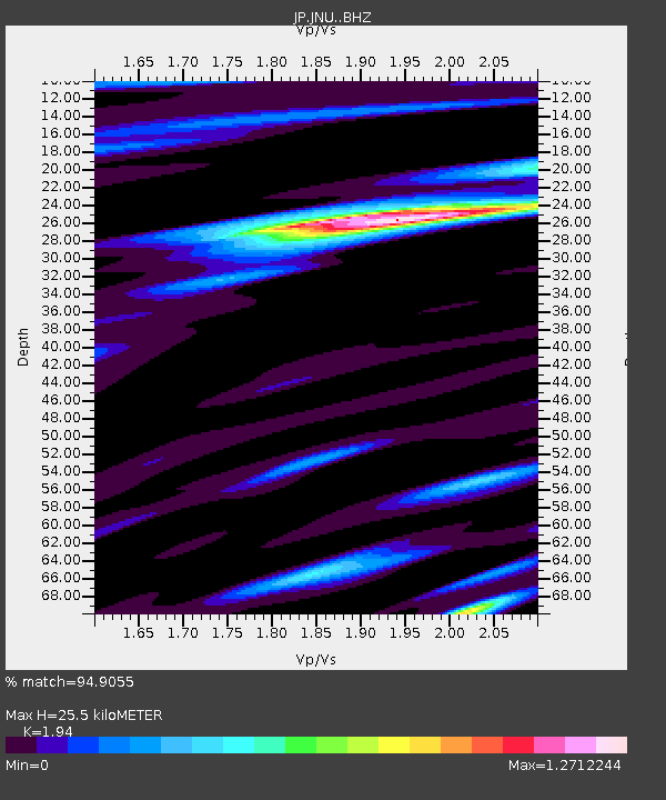
JNU Oita Nakatsue - Earthquake Result Viewer
| Earthquake location: |
South Of Kermadec Islands |
| Earthquake latitude/longitude: |
-33.3/-177.8 |
| Earthquake time(UTC): |
2020/06/18 (170) 12:49:53 GMT |
| Earthquake Depth: |
10 km |
| Earthquake Magnitude: |
7.4 Mww |
| Earthquake Catalog/Contributor: |
NEIC PDE/us |
|
| Network: |
JP Japan Meteorological Agency Seismic Network |
| Station: |
JNU Oita Nakatsue |
| Lat/Lon: |
33.12 N/130.88 E |
| Elevation: |
540 m |
|
| Distance: |
81.8 deg |
| Az: |
318.585 deg |
| Baz: |
138.681 deg |
| Ray Param: |
0.047328304 |
| Estimated Moho Depth: |
25.5 km |
| Estimated Crust Vp/Vs: |
1.94 |
| Assumed Crust Vp: |
6.468 km/s |
| Estimated Crust Vs: |
3.334 km/s |
| Estimated Crust Poisson's Ratio: |
0.32 |
|
| Radial Match: |
94.9055 % |
| Radial Bump: |
400 |
| Transverse Match: |
88.98883 % |
| Transverse Bump: |
400 |
| SOD ConfigId: |
21709731 |
| Insert Time: |
2020-07-02 13:04:36.226 +0000 |
| GWidth: |
2.5 |
| Max Bumps: |
400 |
| Tol: |
0.001 |
|

Signal To Noise
| Channel | StoN | STA | LTA |
| JP:JNU: :BHZ:20200618T13:01:41.400015Z | 24.349825 | 7.620346E-6 | 3.129528E-7 |
| JP:JNU: :BHN:20200618T13:01:41.400015Z | 6.0441494 | 1.8250659E-6 | 3.0195577E-7 |
| JP:JNU: :BHE:20200618T13:01:41.400015Z | 4.4865437 | 1.777057E-6 | 3.96086E-7 |
| Arrivals |
| Ps | 3.8 SECOND |
| PpPs | 11 SECOND |
| PsPs/PpSs | 15 SECOND |


