You are here: Home > Network List > KG - Korean Seismic Network- KIGAM Stations List
> Station TJN Taejon, Republic of Korea > Earthquake Result Viewer
TJN Taejon, Republic of Korea - Earthquake Result Viewer
| Earthquake location: |
South Of Kermadec Islands |
| Earthquake latitude/longitude: |
-33.3/-177.8 |
| Earthquake time(UTC): |
2020/06/18 (170) 12:49:53 GMT |
| Earthquake Depth: |
10 km |
| Earthquake Magnitude: |
7.4 Mww |
| Earthquake Catalog/Contributor: |
NEIC PDE/us |
|
| Network: |
KG Korean Seismic Network- KIGAM |
| Station: |
TJN Taejon, Republic of Korea |
| Lat/Lon: |
36.38 N/127.36 E |
| Elevation: |
60 m |
|
| Distance: |
86.2 deg |
| Az: |
318.629 deg |
| Baz: |
136.692 deg |
| Ray Param: |
0.044256154 |
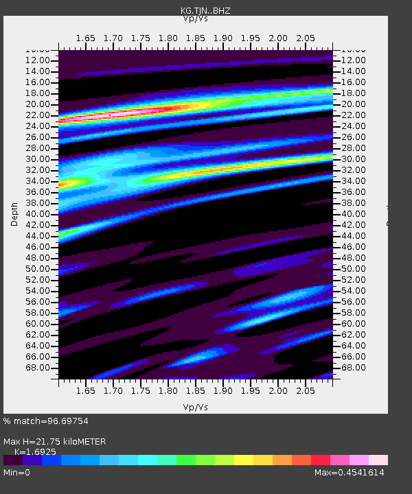
| Estimated Moho Depth: |
21.75 km |
| Estimated Crust Vp/Vs: |
1.69 |
| Assumed Crust Vp: |
6.459 km/s |
| Estimated Crust Vs: |
3.817 km/s |
| Estimated Crust Poisson's Ratio: |
0.23 |
|
| Radial Match: |
96.69754 % |
| Radial Bump: |
236 |
| Transverse Match: |
87.13498 % |
| Transverse Bump: |
400 |
| SOD ConfigId: |
21709731 |
| Insert Time: |
2020-07-02 13:04:46.074 +0000 |
| GWidth: |
2.5 |
| Max Bumps: |
400 |
| Tol: |
0.001 |
|

Signal To Noise
| Channel | StoN | STA | LTA |
| KG:TJN: :BHZ:20200618T13:02:03.518973Z | 19.444632 | 2.8880106E-5 | 1.4852483E-6 |
| KG:TJN: :BHN:20200618T13:02:03.518973Z | 4.5349445 | 7.78454E-6 | 1.7165678E-6 |
| KG:TJN: :BHE:20200618T13:02:03.518973Z | 4.238001 | 6.5703703E-6 | 1.5503466E-6 |
| Arrivals |
| Ps | 2.4 SECOND |
| PpPs | 8.8 SECOND |
| PsPs/PpSs | 11 SECOND |


