You are here: Home > Network List > NN - Western Great Basin/Eastern Sierra Nevada Stations List
> Station KVN Kaiserville, Nevada w84gm > Earthquake Result Viewer
KVN Kaiserville, Nevada w84gm - Earthquake Result Viewer
| Earthquake location: |
South Of Kermadec Islands |
| Earthquake latitude/longitude: |
-33.3/-177.8 |
| Earthquake time(UTC): |
2020/06/18 (170) 12:49:53 GMT |
| Earthquake Depth: |
10 km |
| Earthquake Magnitude: |
7.4 Mww |
| Earthquake Catalog/Contributor: |
NEIC PDE/us |
|
| Network: |
NN Western Great Basin/Eastern Sierra Nevada |
| Station: |
KVN Kaiserville, Nevada w84gm |
| Lat/Lon: |
39.05 N/118.10 W |
| Elevation: |
1829 m |
|
| Distance: |
90.8 deg |
| Az: |
42.27 deg |
| Baz: |
226.343 deg |
| Ray Param: |
0.041674938 |
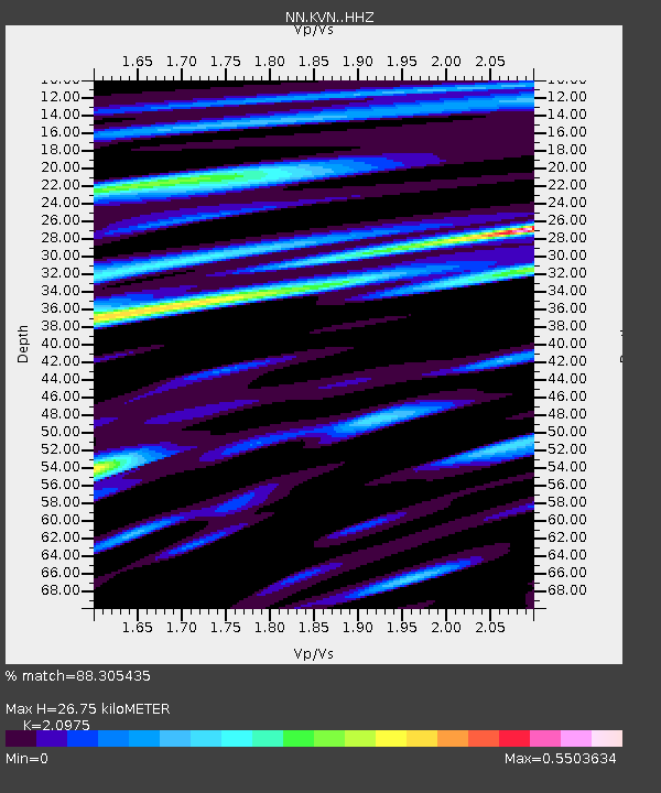
| Estimated Moho Depth: |
26.75 km |
| Estimated Crust Vp/Vs: |
2.10 |
| Assumed Crust Vp: |
6.279 km/s |
| Estimated Crust Vs: |
2.993 km/s |
| Estimated Crust Poisson's Ratio: |
0.35 |
|
| Radial Match: |
88.305435 % |
| Radial Bump: |
373 |
| Transverse Match: |
86.182594 % |
| Transverse Bump: |
400 |
| SOD ConfigId: |
21709731 |
| Insert Time: |
2020-07-02 13:05:18.337 +0000 |
| GWidth: |
2.5 |
| Max Bumps: |
400 |
| Tol: |
0.001 |
|

Signal To Noise
| Channel | StoN | STA | LTA |
| NN:KVN: :HHZ:20200618T13:02:25.504996Z | 39.137554 | 1.7017237E-6 | 4.3480583E-8 |
| NN:KVN: :HHN:20200618T13:02:25.504996Z | 7.373946 | 3.6896697E-7 | 5.003657E-8 |
| NN:KVN: :HHE:20200618T13:02:25.504996Z | 7.3120303 | 3.423885E-7 | 4.6825363E-8 |
| Arrivals |
| Ps | 4.8 SECOND |
| PpPs | 13 SECOND |
| PsPs/PpSs | 18 SECOND |


