You are here: Home > Network List > NN - Western Great Basin/Eastern Sierra Nevada Stations List
> Station MCM07 Monte Cristo Menlo 07 > Earthquake Result Viewer
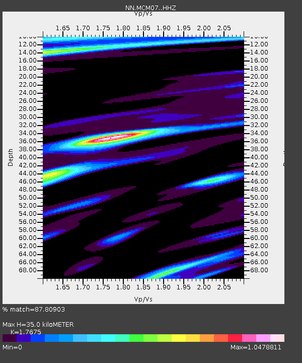
MCM07 Monte Cristo Menlo 07 - Earthquake Result Viewer
| Earthquake location: |
South Of Kermadec Islands |
| Earthquake latitude/longitude: |
-33.3/-177.8 |
| Earthquake time(UTC): |
2020/06/18 (170) 12:49:53 GMT |
| Earthquake Depth: |
10 km |
| Earthquake Magnitude: |
7.4 Mww |
| Earthquake Catalog/Contributor: |
NEIC PDE/us |
|
| Network: |
NN Western Great Basin/Eastern Sierra Nevada |
| Station: |
MCM07 Monte Cristo Menlo 07 |
| Lat/Lon: |
38.23 N/117.75 W |
| Elevation: |
1716 m |
|
| Distance: |
90.4 deg |
| Az: |
43.056 deg |
| Baz: |
226.555 deg |
| Ray Param: |
0.041703373 |
| Estimated Moho Depth: |
35.0 km |
| Estimated Crust Vp/Vs: |
1.77 |
| Assumed Crust Vp: |
6.276 km/s |
| Estimated Crust Vs: |
3.551 km/s |
| Estimated Crust Poisson's Ratio: |
0.26 |
|
| Radial Match: |
87.80903 % |
| Radial Bump: |
400 |
| Transverse Match: |
67.280594 % |
| Transverse Bump: |
400 |
| SOD ConfigId: |
21709731 |
| Insert Time: |
2020-07-02 13:05:51.040 +0000 |
| GWidth: |
2.5 |
| Max Bumps: |
400 |
| Tol: |
0.001 |
|

Signal To Noise
| Channel | StoN | STA | LTA |
| NN:MCM07: :HHZ:20200618T13:02:23.830008Z | 18.07078 | 2.6875646E-6 | 1.4872433E-7 |
| NN:MCM07: :HHN:20200618T13:02:23.830008Z | 2.294301 | 4.1685925E-7 | 1.8169335E-7 |
| NN:MCM07: :HHE:20200618T13:02:23.830008Z | 4.0679936 | 4.921738E-7 | 1.2098687E-7 |
| Arrivals |
| Ps | 4.4 SECOND |
| PpPs | 15 SECOND |
| PsPs/PpSs | 19 SECOND |


