You are here: Home > Network List > S1 - Australian Seismometers in Schools Stations List
> Station AUHAR St Anne's School > Earthquake Result Viewer
AUHAR St Anne's School - Earthquake Result Viewer
| Earthquake location: |
South Of Kermadec Islands |
| Earthquake latitude/longitude: |
-33.3/-177.8 |
| Earthquake time(UTC): |
2020/06/18 (170) 12:49:53 GMT |
| Earthquake Depth: |
10 km |
| Earthquake Magnitude: |
7.4 Mww |
| Earthquake Catalog/Contributor: |
NEIC PDE/us |
|
| Network: |
S1 Australian Seismometers in Schools |
| Station: |
AUHAR St Anne's School |
| Lat/Lon: |
33.09 S/115.89 E |
| Elevation: |
39 m |
|
| Distance: |
54.6 deg |
| Az: |
250.603 deg |
| Baz: |
109.763 deg |
| Ray Param: |
0.06537764 |
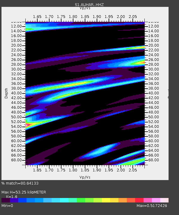
| Estimated Moho Depth: |
53.25 km |
| Estimated Crust Vp/Vs: |
1.60 |
| Assumed Crust Vp: |
6.314 km/s |
| Estimated Crust Vs: |
3.946 km/s |
| Estimated Crust Poisson's Ratio: |
0.18 |
|
| Radial Match: |
80.64133 % |
| Radial Bump: |
400 |
| Transverse Match: |
52.553604 % |
| Transverse Bump: |
400 |
| SOD ConfigId: |
21709731 |
| Insert Time: |
2020-07-02 13:07:17.785 +0000 |
| GWidth: |
2.5 |
| Max Bumps: |
400 |
| Tol: |
0.001 |
|

Signal To Noise
| Channel | StoN | STA | LTA |
| S1:AUHAR: :HHZ:20200618T12:58:50.939993Z | 2.4077492 | 4.843878E-6 | 2.0117866E-6 |
| S1:AUHAR: :HHN:20200618T12:58:50.939993Z | 1.3385687 | 3.7287448E-6 | 2.7856208E-6 |
| S1:AUHAR: :HHE:20200618T12:58:50.939993Z | 0.9631385 | 2.0177742E-6 | 2.094999E-6 |
| Arrivals |
| Ps | 5.4 SECOND |
| PpPs | 21 SECOND |
| PsPs/PpSs | 26 SECOND |


