You are here: Home > Network List > S1 - Australian Seismometers in Schools Stations List
> Station AUKUL Kulin District High School > Earthquake Result Viewer
AUKUL Kulin District High School - Earthquake Result Viewer
| Earthquake location: |
South Of Kermadec Islands |
| Earthquake latitude/longitude: |
-33.3/-177.8 |
| Earthquake time(UTC): |
2020/06/18 (170) 12:49:53 GMT |
| Earthquake Depth: |
10 km |
| Earthquake Magnitude: |
7.4 Mww |
| Earthquake Catalog/Contributor: |
NEIC PDE/us |
|
| Network: |
S1 Australian Seismometers in Schools |
| Station: |
AUKUL Kulin District High School |
| Lat/Lon: |
32.67 S/118.15 E |
| Elevation: |
312 m |
|
| Distance: |
52.9 deg |
| Az: |
251.885 deg |
| Baz: |
109.3 deg |
| Ray Param: |
0.06646267 |
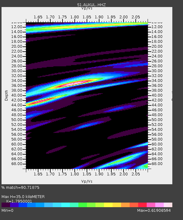
| Estimated Moho Depth: |
35.0 km |
| Estimated Crust Vp/Vs: |
1.80 |
| Assumed Crust Vp: |
6.464 km/s |
| Estimated Crust Vs: |
3.601 km/s |
| Estimated Crust Poisson's Ratio: |
0.27 |
|
| Radial Match: |
90.71875 % |
| Radial Bump: |
400 |
| Transverse Match: |
55.080833 % |
| Transverse Bump: |
400 |
| SOD ConfigId: |
21709731 |
| Insert Time: |
2020-07-02 13:07:22.707 +0000 |
| GWidth: |
2.5 |
| Max Bumps: |
400 |
| Tol: |
0.001 |
|

Signal To Noise
| Channel | StoN | STA | LTA |
| S1:AUKUL: :HHZ:20200618T12:58:38.869986Z | 5.737972 | 4.7427075E-6 | 8.265477E-7 |
| S1:AUKUL: :HHN:20200618T12:58:38.869986Z | 1.0782834 | 1.7355356E-6 | 1.6095356E-6 |
| S1:AUKUL: :HHE:20200618T12:58:38.869986Z | 3.3275962 | 2.6950447E-6 | 8.099074E-7 |
| Arrivals |
| Ps | 4.5 SECOND |
| PpPs | 14 SECOND |
| PsPs/PpSs | 19 SECOND |


