You are here: Home > Network List > TA - USArray Transportable Network (new EarthScope stations) Stations List
> Station M13K Dall Lake, AK, USA > Earthquake Result Viewer
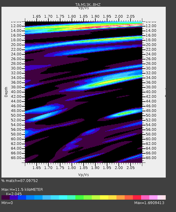
M13K Dall Lake, AK, USA - Earthquake Result Viewer
| Earthquake location: |
South Of Kermadec Islands |
| Earthquake latitude/longitude: |
-33.3/-177.8 |
| Earthquake time(UTC): |
2020/06/18 (170) 12:49:53 GMT |
| Earthquake Depth: |
10 km |
| Earthquake Magnitude: |
7.4 Mww |
| Earthquake Catalog/Contributor: |
NEIC PDE/us |
|
| Network: |
TA USArray Transportable Network (new EarthScope stations) |
| Station: |
M13K Dall Lake, AK, USA |
| Lat/Lon: |
60.41 N/163.35 W |
| Elevation: |
9.0 m |
|
| Distance: |
94.1 deg |
| Az: |
7.15 deg |
| Baz: |
192.127 deg |
| Ray Param: |
0.04111746 |
| Estimated Moho Depth: |
11.5 km |
| Estimated Crust Vp/Vs: |
2.05 |
| Assumed Crust Vp: |
6.1 km/s |
| Estimated Crust Vs: |
2.983 km/s |
| Estimated Crust Poisson's Ratio: |
0.34 |
|
| Radial Match: |
87.09752 % |
| Radial Bump: |
400 |
| Transverse Match: |
67.59421 % |
| Transverse Bump: |
400 |
| SOD ConfigId: |
21709731 |
| Insert Time: |
2020-07-02 13:07:54.072 +0000 |
| GWidth: |
2.5 |
| Max Bumps: |
400 |
| Tol: |
0.001 |
|

Signal To Noise
| Channel | StoN | STA | LTA |
| TA:M13K: :BHZ:20200618T13:02:40.775015Z | 7.2447505 | 2.7230478E-6 | 3.7586494E-7 |
| TA:M13K: :BHN:20200618T13:02:40.775015Z | 1.5917032 | 1.2104009E-6 | 7.604439E-7 |
| TA:M13K: :BHE:20200618T13:02:40.775015Z | 1.4262067 | 7.4175676E-7 | 5.200907E-7 |
| Arrivals |
| Ps | 2.0 SECOND |
| PpPs | 5.7 SECOND |
| PsPs/PpSs | 7.7 SECOND |


