You are here: Home > Network List > TA - USArray Transportable Network (new EarthScope stations) Stations List
> Station M15K Kasigluk River, AK, USA > Earthquake Result Viewer
M15K Kasigluk River, AK, USA - Earthquake Result Viewer
| Earthquake location: |
South Of Kermadec Islands |
| Earthquake latitude/longitude: |
-33.3/-177.8 |
| Earthquake time(UTC): |
2020/06/18 (170) 12:49:53 GMT |
| Earthquake Depth: |
10 km |
| Earthquake Magnitude: |
7.4 Mww |
| Earthquake Catalog/Contributor: |
NEIC PDE/us |
|
| Network: |
TA USArray Transportable Network (new EarthScope stations) |
| Station: |
M15K Kasigluk River, AK, USA |
| Lat/Lon: |
60.69 N/160.69 W |
| Elevation: |
210 m |
|
| Distance: |
94.7 deg |
| Az: |
8.37 deg |
| Baz: |
194.348 deg |
| Ray Param: |
0.040981308 |
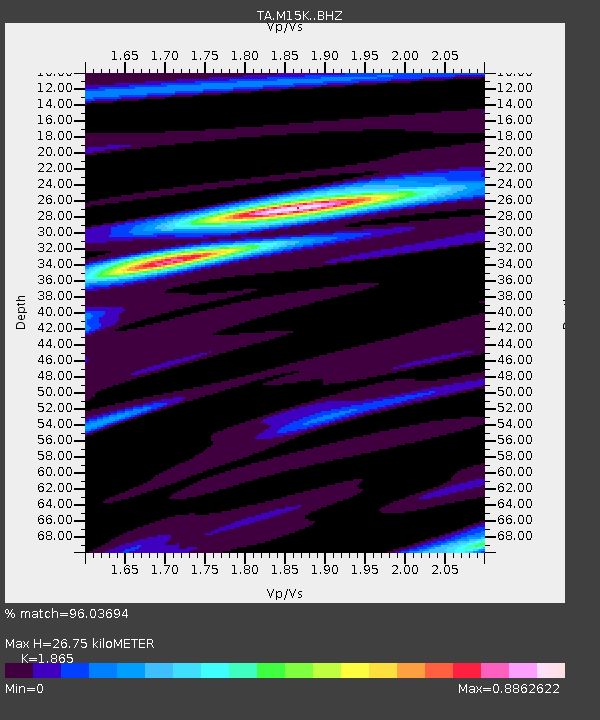
| Estimated Moho Depth: |
26.75 km |
| Estimated Crust Vp/Vs: |
1.87 |
| Assumed Crust Vp: |
6.182 km/s |
| Estimated Crust Vs: |
3.315 km/s |
| Estimated Crust Poisson's Ratio: |
0.30 |
|
| Radial Match: |
96.03694 % |
| Radial Bump: |
388 |
| Transverse Match: |
82.77226 % |
| Transverse Bump: |
400 |
| SOD ConfigId: |
21709731 |
| Insert Time: |
2020-07-02 13:07:56.928 +0000 |
| GWidth: |
2.5 |
| Max Bumps: |
400 |
| Tol: |
0.001 |
|

Signal To Noise
| Channel | StoN | STA | LTA |
| TA:M15K: :BHZ:20200618T13:02:43.374991Z | 17.733961 | 2.7889837E-6 | 1.5726795E-7 |
| TA:M15K: :BHN:20200618T13:02:43.374991Z | 8.044274 | 1.051467E-6 | 1.3070999E-7 |
| TA:M15K: :BHE:20200618T13:02:43.374991Z | 1.6444135 | 2.3292289E-7 | 1.4164497E-7 |
| Arrivals |
| Ps | 3.8 SECOND |
| PpPs | 12 SECOND |
| PsPs/PpSs | 16 SECOND |


