You are here: Home > Network List > TA - USArray Transportable Network (new EarthScope stations) Stations List
> Station Q16K King Salmon, AK, USA > Earthquake Result Viewer
Q16K King Salmon, AK, USA - Earthquake Result Viewer
| Earthquake location: |
South Of Kermadec Islands |
| Earthquake latitude/longitude: |
-33.3/-177.8 |
| Earthquake time(UTC): |
2020/06/18 (170) 12:49:53 GMT |
| Earthquake Depth: |
10 km |
| Earthquake Magnitude: |
7.4 Mww |
| Earthquake Catalog/Contributor: |
NEIC PDE/us |
|
| Network: |
TA USArray Transportable Network (new EarthScope stations) |
| Station: |
Q16K King Salmon, AK, USA |
| Lat/Lon: |
58.68 N/156.66 W |
| Elevation: |
22 m |
|
| Distance: |
93.3 deg |
| Az: |
10.899 deg |
| Baz: |
197.647 deg |
| Ray Param: |
0.041292418 |
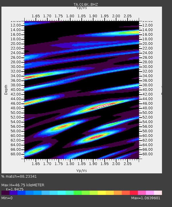
| Estimated Moho Depth: |
46.75 km |
| Estimated Crust Vp/Vs: |
1.94 |
| Assumed Crust Vp: |
6.276 km/s |
| Estimated Crust Vs: |
3.231 km/s |
| Estimated Crust Poisson's Ratio: |
0.32 |
|
| Radial Match: |
88.23341 % |
| Radial Bump: |
400 |
| Transverse Match: |
82.79391 % |
| Transverse Bump: |
400 |
| SOD ConfigId: |
21709731 |
| Insert Time: |
2020-07-02 13:08:17.812 +0000 |
| GWidth: |
2.5 |
| Max Bumps: |
400 |
| Tol: |
0.001 |
|

Signal To Noise
| Channel | StoN | STA | LTA |
| TA:Q16K: :BHZ:20200618T13:02:37.075003Z | 17.602997 | 4.4883973E-6 | 2.5497917E-7 |
| TA:Q16K: :BHN:20200618T13:02:37.075003Z | 4.17676 | 1.9122438E-6 | 4.578294E-7 |
| TA:Q16K: :BHE:20200618T13:02:37.075003Z | 1.2209777 | 5.6977507E-7 | 4.6665477E-7 |
| Arrivals |
| Ps | 7.1 SECOND |
| PpPs | 22 SECOND |
| PsPs/PpSs | 29 SECOND |


