You are here: Home > Network List > TA - USArray Transportable Network (new EarthScope stations) Stations List
> Station U35K Hyder, AK, USA > Earthquake Result Viewer
U35K Hyder, AK, USA - Earthquake Result Viewer
| Earthquake location: |
South Of Kermadec Islands |
| Earthquake latitude/longitude: |
-33.3/-177.8 |
| Earthquake time(UTC): |
2020/06/18 (170) 12:49:53 GMT |
| Earthquake Depth: |
10 km |
| Earthquake Magnitude: |
7.4 Mww |
| Earthquake Catalog/Contributor: |
NEIC PDE/us |
|
| Network: |
TA USArray Transportable Network (new EarthScope stations) |
| Station: |
U35K Hyder, AK, USA |
| Lat/Lon: |
55.92 N/130.03 W |
| Elevation: |
17 m |
|
| Distance: |
97.8 deg |
| Az: |
24.898 deg |
| Baz: |
218.778 deg |
| Ray Param: |
0.04011987 |
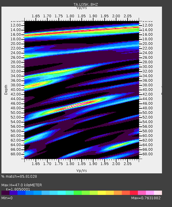
| Estimated Moho Depth: |
47.0 km |
| Estimated Crust Vp/Vs: |
1.81 |
| Assumed Crust Vp: |
6.545 km/s |
| Estimated Crust Vs: |
3.626 km/s |
| Estimated Crust Poisson's Ratio: |
0.28 |
|
| Radial Match: |
85.81028 % |
| Radial Bump: |
400 |
| Transverse Match: |
69.04685 % |
| Transverse Bump: |
400 |
| SOD ConfigId: |
21709731 |
| Insert Time: |
2020-07-02 13:08:22.418 +0000 |
| GWidth: |
2.5 |
| Max Bumps: |
400 |
| Tol: |
0.001 |
|

Signal To Noise
| Channel | StoN | STA | LTA |
| TA:U35K: :BHZ:20200618T13:02:57.124991Z | 4.2233644 | 1.4240519E-6 | 3.3718425E-7 |
| TA:U35K: :BHN:20200618T13:02:57.124991Z | 1.6033138 | 4.0622075E-7 | 2.5336323E-7 |
| TA:U35K: :BHE:20200618T13:02:57.124991Z | 0.92269194 | 2.7692863E-7 | 3.001312E-7 |
| Arrivals |
| Ps | 5.9 SECOND |
| PpPs | 20 SECOND |
| PsPs/PpSs | 26 SECOND |


