You are here: Home > Network List > TX - Texas Seismological Network Stations List
> Station BRDY Brady > Earthquake Result Viewer
BRDY Brady - Earthquake Result Viewer
| Earthquake location: |
South Of Kermadec Islands |
| Earthquake latitude/longitude: |
-33.3/-177.8 |
| Earthquake time(UTC): |
2020/06/18 (170) 12:49:53 GMT |
| Earthquake Depth: |
10 km |
| Earthquake Magnitude: |
7.4 Mww |
| Earthquake Catalog/Contributor: |
NEIC PDE/us |
|
| Network: |
TX Texas Seismological Network |
| Station: |
BRDY Brady |
| Lat/Lon: |
31.27 N/99.00 W |
| Elevation: |
460 m |
|
| Distance: |
98.2 deg |
| Az: |
58.083 deg |
| Baz: |
236.126 deg |
| Ray Param: |
0.039964832 |
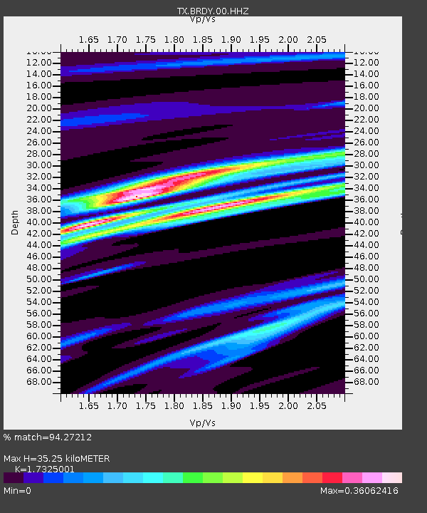
| Estimated Moho Depth: |
35.25 km |
| Estimated Crust Vp/Vs: |
1.73 |
| Assumed Crust Vp: |
6.498 km/s |
| Estimated Crust Vs: |
3.75 km/s |
| Estimated Crust Poisson's Ratio: |
0.25 |
|
| Radial Match: |
94.27212 % |
| Radial Bump: |
240 |
| Transverse Match: |
85.388435 % |
| Transverse Bump: |
400 |
| SOD ConfigId: |
21709731 |
| Insert Time: |
2020-07-02 13:08:43.399 +0000 |
| GWidth: |
2.5 |
| Max Bumps: |
400 |
| Tol: |
0.001 |
|

Signal To Noise
| Channel | StoN | STA | LTA |
| TX:BRDY:00:HHZ:20200618T13:02:59.335013Z | 26.478725 | 1.8022412E-6 | 6.806374E-8 |
| TX:BRDY:00:HH1:20200618T13:02:59.335013Z | 8.942579 | 5.223967E-7 | 5.8416784E-8 |
| TX:BRDY:00:HH2:20200618T13:02:59.335013Z | 9.503329 | 3.517532E-7 | 3.701368E-8 |
| Arrivals |
| Ps | 4.1 SECOND |
| PpPs | 15 SECOND |
| PsPs/PpSs | 19 SECOND |


