You are here: Home > Network List > TX - Texas Seismological Network Stations List
> Station EF02 Christine > Earthquake Result Viewer
EF02 Christine - Earthquake Result Viewer
| Earthquake location: |
South Of Kermadec Islands |
| Earthquake latitude/longitude: |
-33.3/-177.8 |
| Earthquake time(UTC): |
2020/06/18 (170) 12:49:53 GMT |
| Earthquake Depth: |
10 km |
| Earthquake Magnitude: |
7.4 Mww |
| Earthquake Catalog/Contributor: |
NEIC PDE/us |
|
| Network: |
TX Texas Seismological Network |
| Station: |
EF02 Christine |
| Lat/Lon: |
28.78 N/98.53 W |
| Elevation: |
96 m |
|
| Distance: |
97.2 deg |
| Az: |
60.397 deg |
| Baz: |
236.051 deg |
| Ray Param: |
0.04029251 |
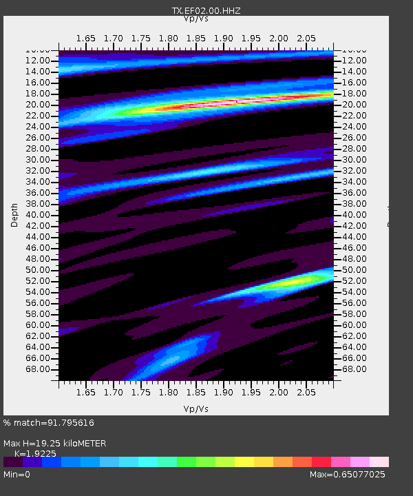
| Estimated Moho Depth: |
19.25 km |
| Estimated Crust Vp/Vs: |
1.92 |
| Assumed Crust Vp: |
6.347 km/s |
| Estimated Crust Vs: |
3.301 km/s |
| Estimated Crust Poisson's Ratio: |
0.31 |
|
| Radial Match: |
91.795616 % |
| Radial Bump: |
398 |
| Transverse Match: |
91.79561 % |
| Transverse Bump: |
398 |
| SOD ConfigId: |
21709731 |
| Insert Time: |
2020-07-02 13:08:47.135 +0000 |
| GWidth: |
2.5 |
| Max Bumps: |
400 |
| Tol: |
0.001 |
|

Signal To Noise
| Channel | StoN | STA | LTA |
| TX:EF02:00:HHZ:20200618T13:02:54.619986Z | 10.830477 | 1.6942631E-6 | 1.5643477E-7 |
| TX:EF02:00:HHN:20200618T13:02:54.619986Z | 1.3690511 | 3.7871894E-7 | 2.766288E-7 |
| $trig.getChannelId() | $trig.getValue() | $trig.getSTA() | $trig.getLTA() |
| Arrivals |
| Ps | 2.8 SECOND |
| PpPs | 8.7 SECOND |
| PsPs/PpSs | 12 SECOND |


