You are here: Home > Network List > TX - Texas Seismological Network Stations List
> Station MB04 Seminole > Earthquake Result Viewer
MB04 Seminole - Earthquake Result Viewer
| Earthquake location: |
South Of Kermadec Islands |
| Earthquake latitude/longitude: |
-33.3/-177.8 |
| Earthquake time(UTC): |
2020/06/18 (170) 12:49:53 GMT |
| Earthquake Depth: |
10 km |
| Earthquake Magnitude: |
7.4 Mww |
| Earthquake Catalog/Contributor: |
NEIC PDE/us |
|
| Network: |
TX Texas Seismological Network |
| Station: |
MB04 Seminole |
| Lat/Lon: |
32.63 N/102.49 W |
| Elevation: |
956 m |
|
| Distance: |
96.6 deg |
| Az: |
55.267 deg |
| Baz: |
234.655 deg |
| Ray Param: |
0.040478162 |
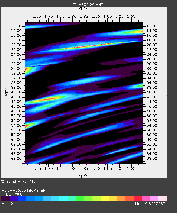
| Estimated Moho Depth: |
20.25 km |
| Estimated Crust Vp/Vs: |
1.86 |
| Assumed Crust Vp: |
6.129 km/s |
| Estimated Crust Vs: |
3.304 km/s |
| Estimated Crust Poisson's Ratio: |
0.30 |
|
| Radial Match: |
94.6247 % |
| Radial Bump: |
400 |
| Transverse Match: |
62.609013 % |
| Transverse Bump: |
400 |
| SOD ConfigId: |
21709731 |
| Insert Time: |
2020-07-02 13:08:52.442 +0000 |
| GWidth: |
2.5 |
| Max Bumps: |
400 |
| Tol: |
0.001 |
|

Signal To Noise
| Channel | StoN | STA | LTA |
| TX:MB04:00:HHZ:20200618T13:02:51.830008Z | 20.036243 | 1.097113E-6 | 5.475642E-8 |
| TX:MB04:00:HH1:20200618T13:02:51.830008Z | 0.3666135 | 1.0344122E-7 | 2.821533E-7 |
| TX:MB04:00:HH2:20200618T13:02:51.830008Z | 4.309013 | 3.364745E-7 | 7.808621E-8 |
| Arrivals |
| Ps | 2.9 SECOND |
| PpPs | 9.3 SECOND |
| PsPs/PpSs | 12 SECOND |


